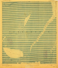
1894 Map of Bayou De Large
USGS Topo · Published 1913About this map
Lake Washa and the expansive wetlands of Terrebonne Parish dominate this late 19th-century landscape, captured shortly before major environmental changes and coastal erosion altered the region's geography. The map emphasizes the intricate hydrology of the Louisiana coast, where Bayou de Large serves as a primary artery of transportation and settlement amidst the marsh. Unlike modern maps of the region, the 1890 survey records the original contours of water bodies like Lake de Cade and the winding course of Bayou Grand Caillou at the edge of Caillou Lake. The absence of roads and the concentration of structures along the higher ground of the bayou levees illustrate the water-dependent economy and lifestyle of the period, providing a baseline for researchers studying the historical shoreline and early maritime life in Southern Louisiana.
Find a feature on this map
9 named features on this map. Tap any name to fly to it.
Don’t see what you’re looking for? This feature index may not catch every label — zoom into the map to look around manually.
Map Details
Editions of this 1894 Bayou De Large Map
4 editions found
Other maps of this area

1892 · Gibson
USGS Topo · 1:62,500

1892 · Houma
USGS Topo · 1:62,500

1894 · Bayou De Large
USGS Topo · 1:62,500

1894 · Dulac
USGS Topo · 1:62,500

1897 · Gibson
USGS Topo · 1:62,500

1932 · Lake Decade
USGS Topo · 1:62,500

1932 · Houma SW
USGS Topo · 1:31,680

1935 · Cocodrie
USGS Topo · 1:31,680

1935 · Theriot
USGS Topo · 1:31,680

1935 · Morgan City
USGS Topo · 1:62,500