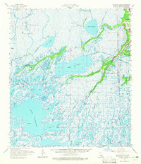
1964 Map of Bayou Du Large
USGS Topo · Published 1965About this map
Bayou Du Large snakes through this expansive marshland in the mid-1960s, anchoring a community defined by its proximity to the Gulf. The settlement of Theriot serves as the local hub along the Marmande Ridge, where the landscape transitions from solid ground to an intricate network of waterways like Lake De Cade and Lake Theriot. The map reveals the deep-rooted cultural fabric of the parish through landmarks such as Bayou du Large Ch, Immaculate Conception Ch, and the Lower Bayou du Large Sch.
Find a feature on this map
60 named features on this map. Tap any name to fly to it.
Don’t see what you’re looking for? This feature index may not catch every label — zoom into the map to look around manually.
Map Details
Editions of this 1964 Bayou Du Large Map
3 editions found
Other maps of this area

1892 · Gibson
USGS Topo · 1:62,500

1892 · Houma
USGS Topo · 1:62,500

1894 · Bayou De Large
USGS Topo · 1:62,500

1894 · Dulac
USGS Topo · 1:62,500

1897 · Gibson
USGS Topo · 1:62,500

1932 · Lake Decade
USGS Topo · 1:62,500

1932 · Houma SW
USGS Topo · 1:31,680

1935 · Cocodrie
USGS Topo · 1:31,680

1935 · Theriot
USGS Topo · 1:31,680

1935 · Morgan City
USGS Topo · 1:62,500