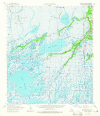
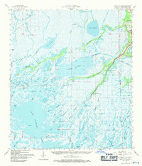
1964 Map of Bayou Du Large
USGS Topo · Published 1965About this map
Bayou Du Large snakes through this expansive marshland in the mid-1960s, anchoring a community defined by its proximity to the Gulf. The settlement of Theriot serves as the local hub along the Marmande Ridge, where the landscape transitions from solid ground to an intricate network of waterways like Lake De Cade and Lake Theriot. The map reveals the deep-rooted cultural fabric of the parish through landmarks such as Bayou du Large Ch, Immaculate Conception Ch, and the Lower Bayou du Large Sch.
Find a feature on this map
60 named features on this map. Tap any name to fly to it.
Don’t see what you’re looking for? This feature index may not catch every label — zoom into the map to look around manually.
Map Details
Editions of this 1964 Bayou Du Large Map
3 editions found
Historical Maps of Theriot Through Time
259 maps found

1892 Gibson
Terrebonne Parish, LA

1894 Bayou De Large
Terrebonne Parish, LA

1897 Gibson
Terrebonne Parish, LA

1932 Houma SW
Terrebonne Parish, LA

1932 Lake Decade
Terrebonne Parish, LA

1935 Bourbeux
Terrebonne Parish, LA

1935 Cocodrie
Terrebonne Parish, LA

1935 Lake Gero
Terrebonne Parish, LA

1935 Lake Mechant
Terrebonne Parish, LA

1935 Lake Penchant
Terrebonne Parish, LA

1935 Lake Quitman
Terrebonne Parish, LA

1935 Oyster Bayou
Terrebonne Parish, LA

1935 Theriot
Terrebonne Parish, LA

1935 Timbalier Island
Terrebonne Parish, LA

1939 Gibson
Terrebonne Parish, LA

1940 Bayou Du Large
Terrebonne Parish, LA

1941 Bayou Du Large
Terrebonne Parish, LA

1941 Gibson
Terrebonne Parish, LA

1944 Bayou Du Large
Terrebonne Parish, LA

1944 Gibson
Terrebonne Parish, LA

1945 Cocodrie
Terrebonne Parish, LA

1945 Lake La Graisse
Terrebonne Parish, LA

1946 Lake La Graisse
Terrebonne Parish, LA

1947 Jacko Bay
Terrebonne Parish, LA

1947 West Derniere
Terrebonne Parish, LA

1949 Dog Lake
Terrebonne Parish, LA

1949 Grand Bayou Du Large
Terrebonne Parish, LA

1950 Derniere
Terrebonne Parish, LA

1953 Cat Island Pass
Terrebonne Parish, LA

1953 Central Isles Dernieres
Terrebonne Parish, LA

1953 Dog Lake
Terrebonne Parish, LA

1953 Eastern Isles Dernieres
Terrebonne Parish, LA

1953 Grand Bayou Du Large
Terrebonne Parish, LA

1953 Jacko Bay
Terrebonne Parish, LA

1953 Timbalier Island
Terrebonne Parish, LA

1953 Western Isles Dernieres
Terrebonne Parish, LA

1954 Lake Felicity
Terrebonne Parish, LA

1956 Lake La Graisse
Terrebonne Parish, LA

1957 Cocodrie
Terrebonne Parish, LA

1957 Lost Lake
Terrebonne Parish, LA

1957 Oyster Bayou
Terrebonne Parish, LA

1964 Bayou Cocodrie
Terrebonne Parish, LA

1964 Bayou Du Large
Terrebonne Parish, LA

1964 Bayou Sauveur
Terrebonne Parish, LA

1964 Gibson
Terrebonne Parish, LA

1964 Gibson
Terrebonne Parish, LA

1964 Humphreys
Terrebonne Parish, LA

1964 Lake Felicity
Terrebonne Parish, LA

1964 Lake Mechant
Terrebonne Parish, LA

1964 Lake Penchant
Terrebonne Parish, LA

1964 Lake Quitman
Terrebonne Parish, LA

1964 Lake Tambour
Terrebonne Parish, LA

1964 Lake Theriot
Terrebonne Parish, LA

1966 Morgan City SE
Terrebonne Parish, LA

1966 Morgan City SW
Terrebonne Parish, LA

1970 Point Au Fer NE
Terrebonne Parish, LA

1970 Point Au Fer
Terrebonne Parish, LA

1974 Carencro Bayou
Terrebonne Parish, LA

1974 East Bay Junop
Terrebonne Parish, LA

1974 Fourleague Bay
Terrebonne Parish, LA

1974 Lost Lake
Terrebonne Parish, LA

1974 Oyster Bayou
Terrebonne Parish, LA

1974 Plumb Bayou
Terrebonne Parish, LA

1983 Atchafalaya Bay
Terrebonne Parish, LA

1983 Terrebonne Bay
Terrebonne Parish, LA

1994 Bayou Sauveur
Terrebonne Parish, LA

1994 Cat Island Pass
Terrebonne Parish, LA

1994 Central Isles Dernieres
Terrebonne Parish, LA

1994 Cocodrie
Terrebonne Parish, LA

1994 Dog Lake
Terrebonne Parish, LA

1994 Eastern Isles Dernieres
Terrebonne Parish, LA

1994 Grand Bayou Du Large
Terrebonne Parish, LA

1994 Jacko Bay
Terrebonne Parish, LA

1994 Lake Felicity
Terrebonne Parish, LA

1994 Lake La Graisse
Terrebonne Parish, LA

1994 Lake Mechant
Terrebonne Parish, LA

1994 Lake Penchant
Terrebonne Parish, LA

1994 Lake Quitman
Terrebonne Parish, LA

1994 Lake Tambour
Terrebonne Parish, LA

1994 Lake Theriot
Terrebonne Parish, LA

1994 Morgan City SE
Terrebonne Parish, LA

1994 Morgan City SW
Terrebonne Parish, LA

1994 Point Au Fer NE
Terrebonne Parish, LA

1994 Timbalier Island
Terrebonne Parish, LA

1994 Western Isles Dernieres
Terrebonne Parish, LA

1998 Central Isles Dernieres
Terrebonne Parish, LA

1998 Dog Lake
Terrebonne Parish, LA

1998 East Bay Junop
Terrebonne Parish, LA

1998 Eastern Isles Dernieres
Terrebonne Parish, LA

1998 Gibson
Terrebonne Parish, LA

1998 Humphreys
Terrebonne Parish, LA

1998 Lost Lake
Terrebonne Parish, LA

1998 Plumb Bayou
Terrebonne Parish, LA

1998 Point Au Fer NE
Terrebonne Parish, LA

1998 Point Au Fer
Terrebonne Parish, LA

2012 Bayou Cocodrie
Terrebonne Parish, LA

2012 Bayou Sauveur
Terrebonne Parish, LA

2012 Carencro Bayou
Terrebonne Parish, LA

2012 Cat Island Pass
Terrebonne Parish, LA

2012 Central Isles Dernieres
Terrebonne Parish, LA

2012 Cocodrie
Terrebonne Parish, LA

2012 Dog Lake
Terrebonne Parish, LA

2012 East Bay Junop
Terrebonne Parish, LA

2012 Eastern Isles Dernieres
Terrebonne Parish, LA

2012 Fourleague Bay
Terrebonne Parish, LA

2012 Gibson
Terrebonne Parish, LA

2012 Grand Bayou du Large
Terrebonne Parish, LA

2012 Humphreys
Terrebonne Parish, LA

2012 Jacko Bay
Terrebonne Parish, LA

2012 Lake Felicity
Terrebonne Parish, LA

2012 Lake La Graisse
Terrebonne Parish, LA

2012 Lake Mechant
Terrebonne Parish, LA

2012 Lake Penchant
Terrebonne Parish, LA

2012 Lake Quitman
Terrebonne Parish, LA

2012 Lake Tambour
Terrebonne Parish, LA

2012 Lake Theriot
Terrebonne Parish, LA

2012 Lost Lake
Terrebonne Parish, LA

2012 Morgan City SE
Terrebonne Parish, LA

2012 Morgan City SW
Terrebonne Parish, LA

2012 Oyster Bayou
Terrebonne Parish, LA

2012 Plumb Bayou
Terrebonne Parish, LA

2012 Point au Fer NE
Terrebonne Parish, LA

2012 Point au Fer OE S
Terrebonne Parish, LA

2012 Point au Fer
Terrebonne Parish, LA

2012 Timbalier Island
Terrebonne Parish, LA

2012 Western Isles Dernieres
Terrebonne Parish, LA

2015 Bayou Cocodrie
Terrebonne Parish, LA

2015 Bayou Sauveur
Terrebonne Parish, LA

2015 Carencro Bayou
Terrebonne Parish, LA

2015 Cat Island Pass
Terrebonne Parish, LA

2015 Central Isles Dernieres
Terrebonne Parish, LA

2015 Cocodrie
Terrebonne Parish, LA

2015 Dog Lake
Terrebonne Parish, LA

2015 East Bay Junop
Terrebonne Parish, LA

2015 Eastern Isles Dernieres
Terrebonne Parish, LA

2015 Fourleague Bay
Terrebonne Parish, LA

2015 Gibson
Terrebonne Parish, LA

2015 Grand Bayou du Large
Terrebonne Parish, LA

2015 Humphreys
Terrebonne Parish, LA

2015 Jacko Bay
Terrebonne Parish, LA

2015 Lake Felicity
Terrebonne Parish, LA

2015 Lake La Graisse
Terrebonne Parish, LA

2015 Lake Mechant
Terrebonne Parish, LA

2015 Lake Penchant
Terrebonne Parish, LA

2015 Lake Quitman
Terrebonne Parish, LA

2015 Lake Tambour
Terrebonne Parish, LA

2015 Lake Theriot
Terrebonne Parish, LA

2015 Lost Lake
Terrebonne Parish, LA

2015 Morgan City SE
Terrebonne Parish, LA

2015 Morgan City SW
Terrebonne Parish, LA

2015 Oyster Bayou
Terrebonne Parish, LA

2015 Plumb Bayou
Terrebonne Parish, LA

2015 Point au Fer NE
Terrebonne Parish, LA

2015 Point au Fer OE S
Terrebonne Parish, LA

2015 Point au Fer
Terrebonne Parish, LA

2015 Timbalier Island
Terrebonne Parish, LA

2015 Western Isles Dernieres
Terrebonne Parish, LA

2018 Bayou Cocodrie
Terrebonne Parish, LA

2018 Bayou Sauveur
Terrebonne Parish, LA

2018 Carencro Bayou
Terrebonne Parish, LA

2018 Cat Island Pass
Terrebonne Parish, LA

2018 Central Isles Dernieres
Terrebonne Parish, LA

2018 Cocodrie
Terrebonne Parish, LA

2018 Dog Lake
Terrebonne Parish, LA

2018 East Bay Junop
Terrebonne Parish, LA

2018 Eastern Isles Dernieres
Terrebonne Parish, LA

2018 Fourleague Bay
Terrebonne Parish, LA

2018 Gibson
Terrebonne Parish, LA

2018 Grand Bayou du Large
Terrebonne Parish, LA

2018 Humphreys
Terrebonne Parish, LA

2018 Jacko Bay
Terrebonne Parish, LA

2018 Lake Felicity
Terrebonne Parish, LA

2018 Lake La Graisse
Terrebonne Parish, LA

2018 Lake Mechant
Terrebonne Parish, LA

2018 Lake Penchant
Terrebonne Parish, LA

2018 Lake Quitman
Terrebonne Parish, LA

2018 Lake Tambour
Terrebonne Parish, LA

2018 Lake Theriot
Terrebonne Parish, LA

2018 Lost Lake
Terrebonne Parish, LA

2018 Morgan City SE
Terrebonne Parish, LA

2018 Morgan City SW
Terrebonne Parish, LA

2018 Oyster Bayou
Terrebonne Parish, LA

2018 Plumb Bayou
Terrebonne Parish, LA

2018 Point au Fer NE
Terrebonne Parish, LA

2018 Point au Fer OE S
Terrebonne Parish, LA

2018 Point au Fer
Terrebonne Parish, LA

2018 Timbalier Island
Terrebonne Parish, LA

2018 Western Isles Dernieres
Terrebonne Parish, LA

2020 Bayou Cocodrie
Terrebonne Parish, LA

2020 Bayou Sauveur
Terrebonne Parish, LA

2020 Carencro Bayou
Terrebonne Parish, LA

2020 Cat Island Pass
Terrebonne Parish, LA

2020 Central Isles Dernieres
Terrebonne Parish, LA

2020 Cocodrie
Terrebonne Parish, LA

2020 Dog Lake
Terrebonne Parish, LA

2020 East Bay Junop
Terrebonne Parish, LA

2020 Eastern Isles Dernieres
Terrebonne Parish, LA

2020 Fourleague Bay
Terrebonne Parish, LA

2020 Gibson
Terrebonne Parish, LA

2020 Grand Bayou du Large
Terrebonne Parish, LA

2020 Humphreys
Terrebonne Parish, LA

2020 Jacko Bay
Terrebonne Parish, LA

2020 Lake Felicity
Terrebonne Parish, LA

2020 Lake Mechant
Terrebonne Parish, LA

2020 Lake Penchant
Terrebonne Parish, LA

2020 Lake Quitman
Terrebonne Parish, LA

2020 Lake Tambour
Terrebonne Parish, LA

2020 Lake Theriot
Terrebonne Parish, LA

2020 Lost Lake
Terrebonne Parish, LA

2020 Morgan City SE
Terrebonne Parish, LA

2020 Morgan City SW
Terrebonne Parish, LA

2020 Oyster Bayou
Terrebonne Parish, LA

2020 Plumb Bayou
Terrebonne Parish, LA

2020 Point au Fer NE
Terrebonne Parish, LA

2020 Point au Fer OE S
Terrebonne Parish, LA

2020 Point au Fer
Terrebonne Parish, LA

2020 Timbalier Island
Terrebonne Parish, LA

2020 Western Isles Dernieres
Terrebonne Parish, LA

2021 Lake La Graisse
Terrebonne Parish, LA

2024 Bayou Cocodrie
Terrebonne Parish, LA

2024 Bayou Sauveur
Terrebonne Parish, LA

2024 Carencro Bayou
Terrebonne Parish, LA

2024 Cat Island Pass
Terrebonne Parish, LA

2024 Central Isles Dernieres
Terrebonne Parish, LA

2024 Cocodrie
Terrebonne Parish, LA

2024 Dog Lake
Terrebonne Parish, LA

2024 East Bay Junop
Terrebonne Parish, LA

2024 Eastern Isles Dernieres
Terrebonne Parish, LA

2024 Fourleague Bay
Terrebonne Parish, LA

2024 Gibson
Terrebonne Parish, LA

2024 Grand Bayou du Large
Terrebonne Parish, LA

2024 Humphreys
Terrebonne Parish, LA

2024 Jacko Bay
Terrebonne Parish, LA

2024 Lake Felicity
Terrebonne Parish, LA

2024 Lake La Graisse
Terrebonne Parish, LA

2024 Lake Mechant
Terrebonne Parish, LA

2024 Lake Penchant
Terrebonne Parish, LA

2024 Lake Quitman
Terrebonne Parish, LA

2024 Lake Tambour
Terrebonne Parish, LA

2024 Lake Theriot
Terrebonne Parish, LA

2024 Lost Lake
Terrebonne Parish, LA

2024 Morgan City SE
Terrebonne Parish, LA

2024 Morgan City SW
Terrebonne Parish, LA

2024 Oyster Bayou
Terrebonne Parish, LA

2024 Plumb Bayou
Terrebonne Parish, LA

2024 Point au Fer NE
Terrebonne Parish, LA

2024 Point au Fer OE S
Terrebonne Parish, LA

2024 Point au Fer
Terrebonne Parish, LA

2024 Timbalier Island
Terrebonne Parish, LA

2024 Western Isles Dernieres
Terrebonne Parish, LA

2025 Cat Island Pass
Terrebonne Parish, LA

2025 Central Isles Dernieres
Terrebonne Parish, LA

2025 East Bay Junop
Terrebonne Parish, LA

2025 Eastern Isles Dernieres
Terrebonne Parish, LA

2025 Oyster Bayou
Terrebonne Parish, LA

2025 Point au Fer OE S
Terrebonne Parish, LA

2025 Point au Fer
Terrebonne Parish, LA

2025 Timbalier Island
Terrebonne Parish, LA

2025 Western Isles Dernieres
Terrebonne Parish, LA