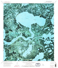
1974 Map of Lost Lake
USGS Topo · Published 1976About this map
The vast wetlands of Terrebonne Parish are dominated by the circular expanse of Lost Lake, a central feature in this 1974 orthophotomap. This specialized survey combines aerial photography with traditional topographic data, revealing the intricate labyrinth of the Louisiana coast before significant modern erosion and sea-level changes. The landscape is a network of interconnected waterways, where Blue Hammock Bayou and Rice Bayou snake through marshy islands. Industrial activity is visible in the form of a Pipeline and scattered energy infrastructure like a Gas Well near Lake Pagie. To the south, the map details the transition into larger bodies of water such as Bay Junop and Mudhole Bay. Points of interest like The Narrows and Plessale Cut provide insight into the natural and man-made navigation routes used by local mariners and industry workers during the mid-1970s.
Find a feature on this map
23 named features on this map. Tap any name to fly to it.
Don’t see what you’re looking for? This feature index may not catch every label — zoom into the map to look around manually.
Map Details
Editions of this 1974 Lost Lake Map
3 editions found
Other maps of this area

1894 · Bayou De Large
USGS Topo · 1:62,500

1932 · Lake Decade
USGS Topo · 1:62,500

1935 · Lake Mechant
USGS Topo · 1:31,680

1935 · Lake Penchant
USGS Topo · 1:31,680

1935 · Oyster Bayou
USGS Topo · 1:62,500

1940 · Bayou Du Large
USGS Topo · 1:62,500

1941 · Bayou Du Large
USGS Topo · 1:62,500

1944 · Bayou Du Large
USGS Topo · 1:62,500

1945 · New Orleans
USGS Topo · 1:250,000

1949 · Grand Bayou Du Large
USGS Topo · 1:31,680