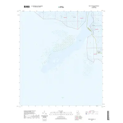
2020 Map of Point au Fer NE
USGS Topo · Published 2020About this map
The Lower Atchafalaya River empties into the expansive Atchafalaya Bay in this coastal region of Southern Louisiana, where the freshwater of the river meets the Gulf tides. This dynamic aquatic landscape is defined by its shifting sediment and deltaic formations, including Shell Island and Deer Island. The boundary between Terrebonne Parish and St. Mary Parish cuts through these waterways, marking a jurisdictional line in a territory dominated by marsh and tide. Navigational channels like Shell Island Pass and Deer Island Pass provide vital routes through the bayous, while smaller features such as Little Hog Bayou and Little Bay illustrate the intricate network of the coastal shelf. The presence of Plumb Island Point and Plumb Island at the eastern edge of the map suggests a fragile, low-lying topography where land and water are in constant flux.
Find a feature on this map
16 named features on this map. Tap any name to fly to it.
Don’t see what you’re looking for? This feature index may not catch every label — zoom into the map to look around manually.
Map Details
Editions of this 2020 Point au Fer NE Map
This is the sole edition of this map. No revisions or reprints were ever made.
Other maps of this area

1932 · Lake Decade
USGS Topo · 1:62,500

1935 · Belle Isle
USGS Topo · 1:31,680

1935 · Morgan City
USGS Topo · 1:62,500

1941 · Belle Isle
USGS Topo · 1:62,500

1945 · New Orleans
USGS Topo · 1:250,000

1954 · Morgan City
USGS Topo · 1:62,500

1954 · Belle Isle
USGS Topo · 1:62,500

1957 · Lake Decade
USGS Topo · 1:62,500

1957 · Point Au Fer
USGS Topo · 1:62,500

1963 · New Orleans
USGS Topo · 1:250,000