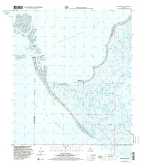
1998 Map of Point Au Fer
USGS Topo · Published 2001About this map
Point Au Fer Island sits at the meeting point of Atchafalaya Bay and the Gulf of Mexico, representing a dynamic coastal landscape defined by shifting water and land. This 1998 survey illustrates the complex maritime geography of the Louisiana coast, where an Indefinite Boundary separates St. Mary and Terrebonne Parishes across the marsh. The map shows the industrial footprint of the Locust Field and a prominent Pipeline Canal, highlighting the intersection of natural wetlands and the regional energy economy. Notable navigational aids like the lighthouse and radio tower on Eugene Island anchor the western edge, while a series of protective coastal features including Shell Reef and Narrow Hammock provide essential structure to this vulnerable shoreline. Waterways such as Raquel Pass and Little Bayou snake through the interior, showing the intricate tidal drainage system typical of this Gulf region.
Find a feature on this map
29 named features on this map. Tap any name to fly to it.
Don’t see what you’re looking for? This feature index may not catch every label — zoom into the map to look around manually.
Map Details
Editions of this 1998 Point Au Fer Map
This is the sole edition of this map. No revisions or reprints were ever made.
Other maps of this area

1932 · Lake Decade
USGS Topo · 1:62,500

1935 · Oyster Bayou
USGS Topo · 1:62,500

1945 · New Orleans
USGS Topo · 1:250,000

1957 · Lake Decade
USGS Topo · 1:62,500
1957 · Oyster Bayou
USGS Topo · 1:62,500

1957 · Point Au Fer
USGS Topo · 1:62,500

1963 · New Orleans
USGS Topo · 1:250,000

1966 · New Orleans
USGS Topo · 1:250,000
1970 · Point Au Fer NE
USGS Topo · 1:24,000
1970 · Point Au Fer
USGS Topo · 1:24,000