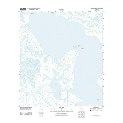
2012 Map of Fourleague Bay
USGS Topo · Published 2012About this map
Fourleague Bay and the surrounding marshlands of Terrebonne Parish dominate this coastal survey, illustrating a landscape defined by the extraction of natural resources. The intrusion of industrial activity into the wetlands is evident through the placement of several energy sites, including the Fourleague Bay Gas Field and the Oyster Bay Oil Field. This hydrographic network is intricate, featuring the expanse of Lake Chapeau and the winding course of Wildcat Bayou. Navigation remains a critical element for this remote region, marked by the Mosquito Point Light situated near Mosquito Point. Landmarks such as South Point and Shell Point define the bay's perimeter, while the interior is fragmented by smaller channels like Mosquito Bayou and Big Carencro Bayou.
Find a feature on this map
14 named features on this map. Tap any name to fly to it.
Don’t see what you’re looking for? This feature index may not catch every label — zoom into the map to look around manually.
Map Details
Editions of this 2012 Fourleague Bay Map
This is the sole edition of this map. No revisions or reprints were ever made.
Other maps of this area

1932 · Lake Decade
USGS Topo · 1:62,500

1935 · Oyster Bayou
USGS Topo · 1:62,500

1945 · New Orleans
USGS Topo · 1:250,000

1957 · Lake Decade
USGS Topo · 1:62,500
1957 · Oyster Bayou
USGS Topo · 1:62,500

1957 · Point Au Fer
USGS Topo · 1:62,500

1963 · New Orleans
USGS Topo · 1:250,000

1966 · New Orleans
USGS Topo · 1:250,000
1970 · Point Au Fer NE
USGS Topo · 1:24,000
1970 · Point Au Fer
USGS Topo · 1:24,000