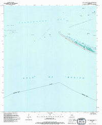
1994 Map of Cat Island Pass
USGS Topo · Published 1994About this map
Timbalier Island anchors this coastal survey, showing a narrow barrier of sand and marsh separating the open Gulf of Mexico from the sheltered waters of Terrebonne Bay and Lake Pelto. In the mid-1990s, the maritime landscape is defined by energy infrastructure, with numerous offshore platforms and tanks dotting the Caillou Island Oil and Gas Field. Navigational aids like a light and Marker No 1 guide vessels through the deep water of Cat Island Pass. The map highlights a dynamic environment where the land is constantly reshaped by the tides, as evidenced by various shoals and the shifting shoreline of the island itself. This record is particularly valuable for documenting the precise footprint of industrial development and the state of Louisiana's fragile barrier islands at the close of the 20th century.
Find a feature on this map
17 named features on this map. Tap any name to fly to it.
Don’t see what you’re looking for? This feature index may not catch every label — zoom into the map to look around manually.
Map Details
Editions of this 1994 Cat Island Pass Map
This is the sole edition of this map. No revisions or reprints were ever made.
Other maps of this area

1894 · Timbalier
USGS Topo · 1:62,500

1935 · Cocodrie
USGS Topo · 1:31,680

1935 · Timbalier Island
USGS Topo · 1:31,680
1945 · Cocodrie
USGS Topo · 1:31,680

1945 · Lake La Graisse
USGS Topo · 1:31,680

1945 · New Orleans
USGS Topo · 1:250,000

1946 · Lake La Graisse
USGS Topo · 1:31,680

1947 · Jacko Bay
USGS Topo · 1:31,680
1953 · Eastern Isles Dernieres
USGS Topo · 1:24,000
1953 · Jacko Bay
USGS Topo · 1:24,000