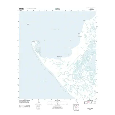
2012 Map of Point au Fer
USGS Topo · Published 2012About this map
Point Au Fer stands at the volatile intersection where the Gulf of Mexico meets the Atchafalaya Bay. This coastal landscape is defined by its intricate network of bayous and hammocks, including Little Hammock and Narrow Hammock, which provide slight elevation amidst the surrounding wetlands. Evidence of Louisiana's coastal industry is centered at the Point Au Fer Oil Field near Locust Bayou, illustrating the economic reach into these tidal marshes.
Find a feature on this map
21 named features on this map. Tap any name to fly to it.
Don’t see what you’re looking for? This feature index may not catch every label — zoom into the map to look around manually.
Map Details
Editions of this 2012 Point au Fer Map
This is the sole edition of this map. No revisions or reprints were ever made.
Other maps of this area

1932 · Lake Decade
USGS Topo · 1:62,500

1935 · Oyster Bayou
USGS Topo · 1:62,500

1945 · New Orleans
USGS Topo · 1:250,000

1957 · Lake Decade
USGS Topo · 1:62,500
1957 · Oyster Bayou
USGS Topo · 1:62,500

1957 · Point Au Fer
USGS Topo · 1:62,500

1963 · New Orleans
USGS Topo · 1:250,000

1966 · New Orleans
USGS Topo · 1:250,000
1970 · Point Au Fer NE
USGS Topo · 1:24,000
1970 · Point Au Fer
USGS Topo · 1:24,000