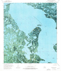
1974 Map of Fourleague Bay
USGS Topo · Published 1976About this map
Point Au Fer Island dominates this mid-1970s orthophotomap, revealing a coastal landscape defined by shifting marshlands and industrial incursions. Located at the intersection of Atchafalaya Bay and Fourleague Bay, the terrain is a complex network of waterways including Mosquito Pass and the winding Wildcat Bayou. The map illustrates the 20th-century extraction economy through the extensive Mosquito Bay Gas Field and numerous offshore platforms, while maritime navigation is marked by the Mosquito Point Light and Oyster Bayou Inner End Light. The transition from the open waters of the Gulf to the sheltered interior of Bay Castagnier and Lake Chapeau is captured through high-altitude aerial photography, providing a clear record of the Louisiana coastline before decades of significant erosion and land loss.
Find a feature on this map
30 named features on this map. Tap any name to fly to it.
Don’t see what you’re looking for? This feature index may not catch every label — zoom into the map to look around manually.
Map Details
Editions of this 1974 Fourleague Bay Map
This is the sole edition of this map. No revisions or reprints were ever made.
Other maps of this area

1932 · Lake Decade
USGS Topo · 1:62,500

1935 · Oyster Bayou
USGS Topo · 1:62,500

1945 · New Orleans
USGS Topo · 1:250,000

1957 · Lake Decade
USGS Topo · 1:62,500
1957 · Oyster Bayou
USGS Topo · 1:62,500

1957 · Point Au Fer
USGS Topo · 1:62,500

1963 · New Orleans
USGS Topo · 1:250,000

1966 · New Orleans
USGS Topo · 1:250,000
1970 · Point Au Fer NE
USGS Topo · 1:24,000
1970 · Point Au Fer
USGS Topo · 1:24,000