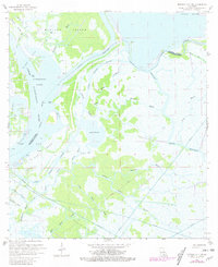
1966 Map of Morgan City SW
USGS Topo · Published 1981About this map
Industrial extraction and tidal waterways define this section of the Louisiana marshlands during the mid-1960s. The landscape is dominated by the Deer Island Gas and Oil Field and the Gas and Oil Field on Bateman Island, marked by numerous drill holes, oil wells, and gas wells. These features represent the significant petroleum infrastructure that reshaped the coastal wetlands, accompanied by an extensive network of pipelines cutting through the soft terrain.
Find a feature on this map
40 named features on this map. Tap any name to fly to it.
Don’t see what you’re looking for? This feature index may not catch every label — zoom into the map to look around manually.
Map Details
Editions of this 1966 Morgan City SW Map
2 editions found
Other maps of this area

1932 · Lake Decade
USGS Topo · 1:62,500

1935 · Morgan City
USGS Topo · 1:62,500

1941 · Belle Isle
USGS Topo · 1:62,500

1945 · New Orleans
USGS Topo · 1:250,000

1954 · Morgan City
USGS Topo · 1:62,500

1954 · Belle Isle
USGS Topo · 1:62,500

1957 · Lake Decade
USGS Topo · 1:62,500

1957 · Point Au Fer
USGS Topo · 1:62,500

1963 · New Orleans
USGS Topo · 1:250,000

1966 · New Orleans
USGS Topo · 1:250,000