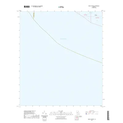
2020 Map of Point au Fer OE S
USGS Topo · Published 2020About this map
The Gulf of Mexico dominates this coastal survey, where the terrestrial landscape is limited to the marshes of Point Au Fer Island in the northeastern corner. This specialized sheet captures the maritime interface of coastal Louisiana at the parish line between St. Mary Parish and Terrebonne Parish. The presence of Burkes Bayou snaking through the land's edge illustrates the tidal nature of this environment, which is largely defined by open water and shifting coastlines. For those studying the ecological and geographic changes of the Louisiana gulf coast, the map provides a precise location for the primary island boundary during this modern period.
Find a feature on this map
4 named features on this map. Tap any name to fly to it.
Don’t see what you’re looking for? This feature index may not catch every label — zoom into the map to look around manually.
Map Details
Editions of this 2020 Point au Fer OE S Map
This is the sole edition of this map. No revisions or reprints were ever made.
Other maps of this area

1932 · Lake Decade
USGS Topo · 1:62,500

1935 · Oyster Bayou
USGS Topo · 1:62,500

1945 · New Orleans
USGS Topo · 1:250,000

1957 · Lake Decade
USGS Topo · 1:62,500
1957 · Oyster Bayou
USGS Topo · 1:62,500

1957 · Point Au Fer
USGS Topo · 1:62,500

1963 · New Orleans
USGS Topo · 1:250,000

1966 · New Orleans
USGS Topo · 1:250,000
1970 · Point Au Fer
USGS Topo · 1:24,000
1974 · Fourleague Bay
USGS Topo · 1:24,000