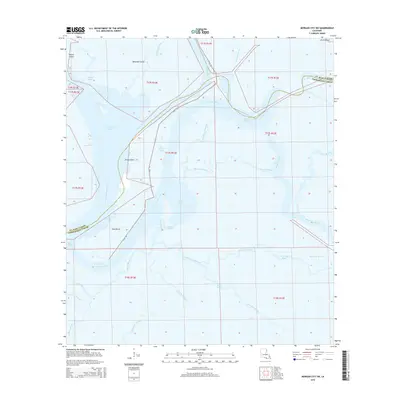
2015 Map of Morgan City SW
USGS Topo · Published 2015About this map
Lower Atchafalaya River and a dense network of coastal distributaries dominate this corner of Terrebonne Parish and St. Mary Parish. The landscape is defined by the hydrologic engineering of the Avoca Island Cutoff and the accompanying Levee Rd, which provides a terrestrial boundary between the river system and the expansive wetlands to the east. Navigable waterways like Bayou Shaffer and Bayou Penchant snake through the marsh, connecting named landforms such as Bateman Island and Honey Island. The intricate web of smaller channels, including Blackbird Bayou and Little Horn Bayou, reflects the dynamic nature of the Mississippi River Delta's southern reaches. This survey captures the region's character as a specialized environment where human infrastructure, represented by the Burke Canal, meets the natural hydrology of Sweetbay Lake and Lake Gascha.
Find a feature on this map
36 named features on this map. Tap any name to fly to it.
Don’t see what you’re looking for? This feature index may not catch every label — zoom into the map to look around manually.
Map Details
Editions of this 2015 Morgan City SW Map
This is the sole edition of this map. No revisions or reprints were ever made.
Other maps of this area

1932 · Lake Decade
USGS Topo · 1:62,500

1935 · Morgan City
USGS Topo · 1:62,500

1941 · Belle Isle
USGS Topo · 1:62,500

1945 · New Orleans
USGS Topo · 1:250,000

1954 · Morgan City
USGS Topo · 1:62,500

1954 · Belle Isle
USGS Topo · 1:62,500

1957 · Lake Decade
USGS Topo · 1:62,500

1957 · Point Au Fer
USGS Topo · 1:62,500

1963 · New Orleans
USGS Topo · 1:250,000

1966 · New Orleans
USGS Topo · 1:250,000