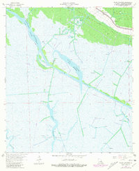
1964 Map of Bayou Cocodrie
USGS Topo · Published 1981About this map
Greenwood sits at the northern edge of this Louisiana landscape, where the agricultural and energy industries of Terrebonne Parish intersect. The 1960s terrain is defined by a complex network of dredging and resource extraction, with the Bayou Cocodrie Waterway and the Intracoastal Waterway cutting through the wetlands. Industrial development is heavy throughout the area, marked by the Gibson Oil Field, Northeast Gibson Field, and numerous scattered drill holes and gas wells. Local landmarks like Mt Pilgrim Ch near Bayou Black provide evidence of established communities amidst the commercial activity. The map reveals the watery geography of the region, tracing Lake Cocodrie and the Bayou Copasaw as they wind through the marsh toward Bayou Penchant. Purple photorevisions from 1978 show how the shoreline and industrial infrastructure evolved in the late twentieth century.
Find a feature on this map
18 named features on this map. Tap any name to fly to it.
Don’t see what you’re looking for? This feature index may not catch every label — zoom into the map to look around manually.
Map Details
Editions of this 1964 Bayou Cocodrie Map
3 editions found
Other maps of this area

1892 · Gibson
USGS Topo · 1:62,500

1894 · Bayou De Large
USGS Topo · 1:62,500

1897 · Gibson
USGS Topo · 1:62,500

1932 · Lake Decade
USGS Topo · 1:62,500

1935 · Theriot
USGS Topo · 1:31,680

1935 · Morgan City
USGS Topo · 1:62,500

1935 · Lake Penchant
USGS Topo · 1:31,680

1939 · Gibson
USGS Topo · 1:62,500

1940 · Bayou Du Large
USGS Topo · 1:62,500

1941 · Bayou Du Large
USGS Topo · 1:62,500