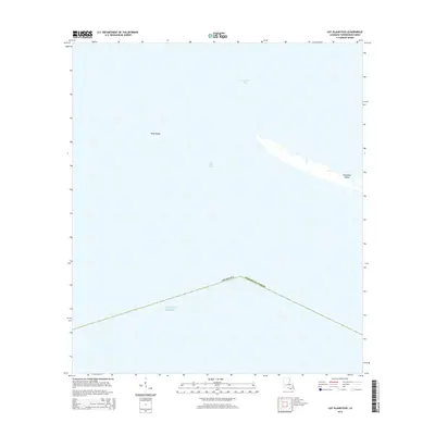
2015 Map of Cat Island Pass
USGS Topo · Published 2015About this map
Timbalier Island and Wine Island stand as coastal sentinels in this 2015 maritime survey of the Louisiana coast. The map focuses on the transition between the open Gulf of Mexico and the interior waters of Terrebonne Bay, connected by the deep-water corridor of Cat Island Pass. This era of documentation reveals the fragmented nature of the barrier island system within Terrebonne Parish, where narrow ribbons of land serve as the primary buffer for the mainland marshes. The sparse terrestrial features emphasize the dynamic and shifting coastline characteristic of this region, providing a specific record of island geometry and channel positioning before further environmental changes.
Find a feature on this map
6 named features on this map. Tap any name to fly to it.
Don’t see what you’re looking for? This feature index may not catch every label — zoom into the map to look around manually.
Map Details
Editions of this 2015 Cat Island Pass Map
This is the sole edition of this map. No revisions or reprints were ever made.
Other maps of this area

1894 · Timbalier
USGS Topo · 1:62,500

1935 · Cocodrie
USGS Topo · 1:31,680

1935 · Timbalier Island
USGS Topo · 1:31,680
1945 · Cocodrie
USGS Topo · 1:31,680

1945 · Lake La Graisse
USGS Topo · 1:31,680

1945 · New Orleans
USGS Topo · 1:250,000

1946 · Lake La Graisse
USGS Topo · 1:31,680

1947 · Jacko Bay
USGS Topo · 1:31,680
1953 · Eastern Isles Dernieres
USGS Topo · 1:24,000
1953 · Jacko Bay
USGS Topo · 1:24,000