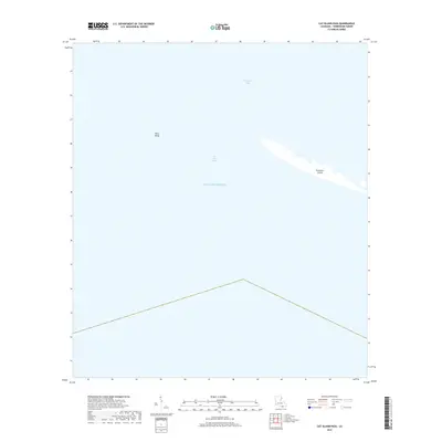
2018 Map of Cat Island Pass
USGS Topo · Published 2018About this map
Timbalier Island and the neighboring barrier islands form a critical buffer between the open Gulf of Mexico and the interior marshes of Terrebonne Parish. This maritime landscape is defined by its shifting shoals and the deep channel of Cat Island Pass, a vital corridor for watercraft moving between the gulf and the sheltered waters of Terrebonne Bay. The map highlights the isolated character of Wine Island, illustrating the fragile coastal topography that characterizes Louisiana's southern frontier. As a study of the interplay between currents and land, the survey reveals a geography in constant flux, where small landmasses serve as the final outposts against the sea. This record captures the precise orientation of these barrier features before further coastal erosion or storms can reshape the seafloor and shoreline profile.
Find a feature on this map
5 named features on this map. Tap any name to fly to it.
Don’t see what you’re looking for? This feature index may not catch every label — zoom into the map to look around manually.
Map Details
Editions of this 2018 Cat Island Pass Map
This is the sole edition of this map. No revisions or reprints were ever made.
Other maps of this area

1894 · Timbalier
USGS Topo · 1:62,500

1935 · Cocodrie
USGS Topo · 1:31,680

1935 · Timbalier Island
USGS Topo · 1:31,680
1945 · Cocodrie
USGS Topo · 1:31,680

1945 · Lake La Graisse
USGS Topo · 1:31,680

1945 · New Orleans
USGS Topo · 1:250,000

1946 · Lake La Graisse
USGS Topo · 1:31,680

1947 · Jacko Bay
USGS Topo · 1:31,680
1953 · Eastern Isles Dernieres
USGS Topo · 1:24,000
1953 · Jacko Bay
USGS Topo · 1:24,000