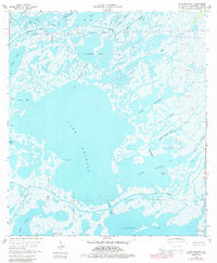
1964 Map of Lake Mechant
USGS Topo · Published 1989About this map
Lake Mechant dominates this coastal landscape in Terrebonne Parish, illustrating the intricate network of waterways defining the Louisiana marshlands during the 1960s. The interplay of saltwater and brackish systems is evidenced by major bodies like Caillou Lake and Mud Lake, connected by natural thoroughfares such as Bayou Du Large and the Grand Pass. This environment is a working landscape, notably featuring the Lake Pagie Gas Field and several scattered drill holes and oil wells, highlighting the mid-century industrial footprint on the wetlands. Local geography is further marked by specific landmarks such as Hog Point and the winding course of Cade Bayou. The map captures a moment before significant coastal erosion altered these boundaries, documenting numerous smaller basins like Raccourci Bay and Lake Washa that serve as critical reference points for environmental and historical study.
Find a feature on this map
32 named features on this map. Tap any name to fly to it.
Don’t see what you’re looking for? This feature index may not catch every label — zoom into the map to look around manually.
Map Details
Editions of this 1964 Lake Mechant Map
4 editions found
Other maps of this area

1894 · Bayou De Large
USGS Topo · 1:62,500

1932 · Lake Decade
USGS Topo · 1:62,500

1935 · Theriot
USGS Topo · 1:31,680

1935 · Lake Mechant
USGS Topo · 1:31,680

1935 · Lake Penchant
USGS Topo · 1:31,680

1935 · Oyster Bayou
USGS Topo · 1:62,500

1940 · Bayou Du Large
USGS Topo · 1:62,500

1941 · Bayou Du Large
USGS Topo · 1:62,500

1944 · Bayou Du Large
USGS Topo · 1:62,500

1945 · New Orleans
USGS Topo · 1:250,000