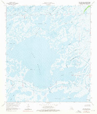
1964 Map of Lake Mechant
USGS Topo · Published 1976About this map
The low-lying coastal marshes of Terrebonne Parish are defined here by a sprawling network of interior bays and intricate waterways as they appeared in the mid-1960s. Dominating the center of the sheet is Lake Mechant, connected to the surrounding marsh complex by Grand Pass and the winding course of Bayou Large. This area illustrates the transition between larger open bodies of water like Caillou Lake and King Lake and the dense tidal flats to the north. Industrial activity in this wetland environment is evidenced by the presence of an Oil Well and several Drill Holes, highlighting the region's reliance on coastal resources. The labyrinthine nature of the landscape is further emphasized by named points and channels such as Hog Point, Bayou Chevreau, and Raccourci Bay.
Find a feature on this map
34 named features on this map. Tap any name to fly to it.
Don’t see what you’re looking for? This feature index may not catch every label — zoom into the map to look around manually.
Map Details
Editions of this 1964 Lake Mechant Map
4 editions found
Other maps of this area

1894 · Bayou De Large
USGS Topo · 1:62,500

1932 · Lake Decade
USGS Topo · 1:62,500

1935 · Theriot
USGS Topo · 1:31,680

1935 · Lake Mechant
USGS Topo · 1:31,680

1935 · Lake Penchant
USGS Topo · 1:31,680

1935 · Oyster Bayou
USGS Topo · 1:62,500

1940 · Bayou Du Large
USGS Topo · 1:62,500

1941 · Bayou Du Large
USGS Topo · 1:62,500

1944 · Bayou Du Large
USGS Topo · 1:62,500

1945 · New Orleans
USGS Topo · 1:250,000