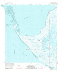
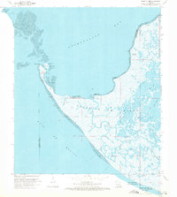
1970 Map of Point Au Fer
USGS Topo · Published 1991About this map
Point Au Fer Island sits at the edge of the Gulf of Mexico, where the shifting coastal landscape of St. Mary and Terrebonne Parishes meets the open water. This 1970 survey, updated with late 1970s revisions, illustrates a remote wetland environment defined by intricate waterways and shell deposits. The arc of the Point Au Fer Shell Reef protects the inner waters of Mullet Cove, while navigation is aided by a Lighthouse and Radio Tower on Eugene Island.
Find a feature on this map
26 named features on this map. Tap any name to fly to it.
Don’t see what you’re looking for? This feature index may not catch every label — zoom into the map to look around manually.
Map Details
Editions of this 1970 Point Au Fer Map
3 editions found
Other maps of this area

1932 · Lake Decade
USGS Topo · 1:62,500

1935 · Oyster Bayou
USGS Topo · 1:62,500

1945 · New Orleans
USGS Topo · 1:250,000

1957 · Lake Decade
USGS Topo · 1:62,500
1957 · Oyster Bayou
USGS Topo · 1:62,500

1957 · Point Au Fer
USGS Topo · 1:62,500

1963 · New Orleans
USGS Topo · 1:250,000

1966 · New Orleans
USGS Topo · 1:250,000
1970 · Point Au Fer NE
USGS Topo · 1:24,000
1970 · Point Au Fer
USGS Topo · 1:24,000