Old Maps of Union Parish, Louisiana for Metal Detecting
Plan your next treasure hunt with 194 historic maps of Union Parish. Find old homesites, ghost towns, trails, and gathering spots that may be lost to time — perfect for identifying promising metal detecting locations.
- Locate forgotten sites: Uncover places like long-lost settlements, abandoned rail lines, or gathering spots.
- Plan better hunts: Use map overlays combined with LiDAR or satellite views to narrow in on historically rich areas.
- Made for detectorists: Thousands of hobbyists use these maps to discover relics, coins, and hidden history.
Use these historic maps to boost your research and find new opportunities beneath the surface of Union Parish.
Union Parish, LA maps
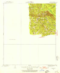
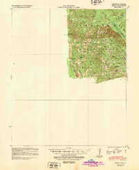
(194)- 1927 Map of El Dorado
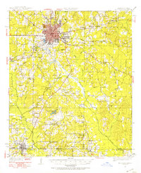
 1927 El Dorado1927 Print · USGSUnion County, Arkansas, is captured here in the late twenties as the oil boom transformed the landscape around El Dorado. Researchers can trace the early footprints of settlements like Caledonia and find rural landmarks such as Old Parker Chapel and Jennys Store.2 unique versions available
 - 1930 Map of El Dorado, 1949 Print
 1930 El Dorado1949 Print · USGSUnion County enters its oil boom era during the late twenties, with this survey capturing the burgeoning industry surrounding El Dorado. Genealogists and local historians can trace rural school districts like Shady Grove Sch and Fairview Sch, or locate family sites near Parnell Cemetery.
 - 1933 Map of Strong, 1954 Print
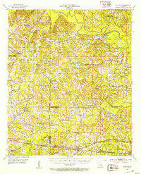
 1933 Strong1954 Print · USGSUnion County, Arkansas, was a landscape of bayous and timber mills during the early 1930s. Genealogists and local historians can trace the rural fabric of the region through landmarks like George Cem, New London, and the Mcclendon Mill.
 - 1934 Map of Felsenthal, 1954 Print
 1934 Felsenthal1954 Print · USGSThe Ouachita and Saline River basins are captured here in the early 1930s as logging and rail shaped the Arkansas-Louisiana border. Trace the industrial footprint of the Logging RR and Missouri Pacific RR alongside local centers like Felsenthal, Huttig, and Smith Chapel.2 unique versions available
 - 1935 Map of Drew, 1947 Print
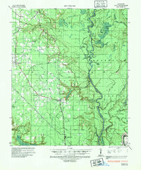
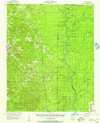
 1935 Drew1947 Print · USGSNorthern Louisiana's river country was defined by winding waterways and emerging energy infrastructure in the 1930s. Genealogists can trace early crossings like Whites Ferry and family-named locales such as Guthrie or the Childrens Home in Monroe.
 - 1935 Map of Haile, 1948 Print
 1935 Haile1948 Print · USGSThe Louisiana bayous and timberlands near the Ouachita River are captured here in the mid-1930s as the regional energy economy began to expand. Genealogists can locate family landmarks like St Pauls Church and the settlement of Marion, or trace industrial roots through the Abandoned Logging Railroad and river landings.
 - 1937 Map of Strong
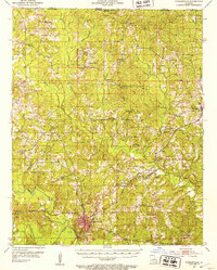
 1937 Strong1937 Print · USGSUnion County and the bayou country of southern Arkansas are captured here during the 1930s. Genealogists and local historians can trace rural roots through landmarks like Wallace Cem, McClendon Mill, and Ebenezer Ch.2 unique versions available
 - 1937 Map of Felsenthal
 1937 Felsenthal1937 Print · USGSThe Ouachita River bottomlands come to life in the mid-1930s, showing a landscape of logging railroads and river bends. Trace family roots through Lapile Cem, Huttig, and Felsenthal, or locate vanished landmarks like Cooter Sch and Dollar Junction.
 - 1938 Map of Felsenthal
 1938 Felsenthal1938 Print · USGSThe river bottoms of south Arkansas and north Louisiana are seen here in the late 1930s, showing a landscape defined by the winding Ouachita River. Genealogists and historians can locate the old townsite of Felsenthal, rural landmarks like Smiths Chapel, and the river landing at Prairie Island Ldg.
 - 1939 Map of Felsenthal
 1939 Felsenthal1939 Print · USGSThe river bottomlands of southern Arkansas and northern Louisiana come alive in the late thirties as the timber industry reshapes the landscape. Researchers can trace the sprawling rail lines of the Missouri Pacific, the industrial layout of Huttig, and rural sites like Smith Chapel or the Macedonian Cem.2 unique versions available
 - 1939 Map of Strong, 1948 Print
 1939 Strong1948 Print · USGSUnion County, Arkansas, comes to life in the 1930s as a land of small timber settlements and rural parishes. Researchers can trace family roots through sites like Ebenezer Cem, McGlendon Mill, and the many schools including Gill Sch.
 - 1950 Map of Ruston, 1956 Print
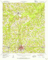 1950 Ruston1956 Print · USGSLincoln Parish at mid-century centers on the expansion of Ruston and the campus of Grambling College during a period of steady growth. Researchers can trace rural lineages through numerous country landmarks like New Prospect Ch, Macedonia Cem, and Culbertson Sch.2 unique versions available
 - 1951 Map of Ruston
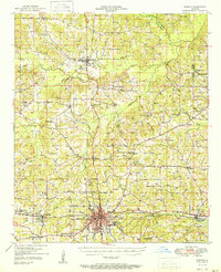 1951 Ruston1951 Print · USGSNorth Louisiana in the early fifties was a landscape of rail-driven towns and deep-rooted rural parishes. Genealogists can trace family landmarks like Henry Cem and Macedonia Ch, or explore the early campus footprint of Grambling College.
 - 1951 Map of Bernice, 1952 Print
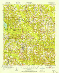 1951 Bernice1952 Print · USGSNorthern Louisiana life centered on the rail lines and creek bottoms in the early fifties. Genealogists can trace family roots through numerous rural landmarks like Hard Shell Cem, Harmony Chapel, and the community of Spearsville.4 unique versions available
 - 1951 Map of El Dorado, 1953 Print
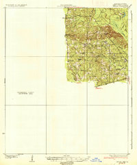
 1951 El Dorado1953 Print · USGSSouthern Arkansas in the early fifties shows a landscape shaped by the Missouri Pacific railroad and rural growth around El Dorado. Genealogists can locate numerous landmarks like Parkers Chapel Sch, Wesley Chapel, and Caledonia.3 unique versions available
 - 1952 Map of Calhoun, 1953 Print
 1952 Calhoun1953 Print · USGSNorth Louisiana life in the early fifties centered on the rural crossroads and rail lines of Union and Ouachita Parishes. Genealogists can trace family footprints through numerous local landmarks like Millard Hill Cem, Auld Chapel, and the Experiment Station at Calhoun.3 unique versions available
 - 1952 Map of Farmerville, 1953 Print
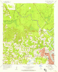
 1952 Farmerville1953 Print · USGSUnion Parish in the early fifties reveals a landscape of tight-knit rural communities and timber-rail corridors. Researchers can locate family landmarks like Old Tennessee Cem, trace the Pacific Railroad, or find long-standing congregations such as Mt Olive Ch.4 unique versions available
 - 1953 Map of El Dorado, 1967 Print
 1953 El Dorado1967 Print · USGSSouth Arkansas in the mid-1960s was a landscape of industrial growth and river-fed commerce. Researchers can trace the extensive Oil and Gas Fields around Magnolia, the expansive U S Naval Ammunition Depot, and the busy rail lines of the Missouri Pacific.3 unique versions available
 - 1955 Map of Shreveport
 1955 Shreveport1955 Print · USGSNorthern Louisiana in the mid-fifties is captured here as a landscape of military bases, vast oil fields, and burgeoning college towns. Genealogists and historians can trace the rail-and-river economy through the Monroe Gas Field, Grambling College, and Barksdale Air Force Base.3 unique versions available
 - 1956 Map of Shreveport
 1956 Shreveport1956 Print · USGSNorthern Louisiana during the mid-fifties presents a complex landscape of booming oil fields and strategic military installations. Genealogists and historians can trace the infrastructure of the Monroe Gas Field and family-named locales from Cotton Valley to Jonesboro.
 - 1956 Map of Haile, 1957 Print
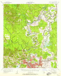
 1956 Haile1957 Print · USGSUnion Parish and the bottomlands of the Quachita River are shown here in the mid-1950s as a landscape of timber, rail, and river landings. Researchers can trace family history through sites like Hollman Sch, St Johns Ch, and the Missouri Pacific line through Haile.4 unique versions available
 - 1957 Map of El Dorado
 1957 El Dorado1957 Print · USGSSouth Arkansas in the mid-1950s was a critical hub of military logistics and rail-river commerce. Genealogists and historians can trace family land across the Arkansas Louisiana border and locate sites like the U.S. Naval Ammunition Depot or the rail junctions at Magnolia and Camden.
 - 1957 Map of Monroe North, 1958 Print
 1957 Monroe North1958 Print · USGSNorth of the city center in the late fifties, the riverfront and bayous define a landscape of growing neighborhoods and industrial sites. Researchers can trace family roots through landmarks like Bean Chapel, Neville High Sch, and the grounds of Selman Airport.2 unique versions available
 - 1957 Map of West Monroe North, 1958 Print
 1957 West Monroe North1958 Print · USGSWest Monroe and its northern rural reaches are captured here during a period of steady mid-century development. Researchers can trace ancestral footprints at Hasley Cem, locate rural landmarks like Goodhope Ch, or follow the Illinois Central rail line through the bayou country.4 unique versions available
 - 1958 Map of El Dorado
 1958 El Dorado1958 Print · USGSSouthern Arkansas and the Louisiana borderlands are shown during a period of heavy rail traffic and defense industry activity. Researchers can trace the legacy of the U. S. Naval Ammunition Depot or locate family roots in Smackover, Huttig, and Nashville.3 unique versions available
Showing maps 1-25 of 194
Top cities of Union Parish
- Farmerville historical maps
- Bernice historical maps
- Marion historical maps
- Spearsville historical maps
- Lillie historical maps
Frequently asked questions
- What are the different types of historical maps available for Union Parish?
- What is the oldest map of Union Parish?
- Where can I purchase historical maps of Union Parish for my home or office?
- Where can I download high-res historical maps of Union Parish?
- Are there historical topographic maps available for Union Parish?
- Is there historical aerial imagery available for Union Parish?
- Where are historical maps of Union Parish sourced from?