Old Maps of Cheniere au Tigre, Louisiana for Metal Detecting
Plan your next treasure hunt with 16 historic maps of Cheniere au Tigre. Find old homesites, ghost towns, trails, and gathering spots that may be lost to time — perfect for identifying promising metal detecting locations.
- Locate forgotten sites: Uncover places like long-lost settlements, abandoned rail lines, or gathering spots.
- Plan better hunts: Use map overlays combined with LiDAR or satellite views to narrow in on historically rich areas.
- Made for detectorists: Thousands of hobbyists use these maps to discover relics, coins, and hidden history.
Use these historic maps to boost your research and find new opportunities beneath the surface of Cheniere au Tigre.
Cheniere au Tigre, LA maps
(16)- 1946 Map of Redfish Point SW
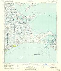
 1946 Redfish Point SW1946 Print · USGSLouisiana's marshy coastline in the 1940s reveals a landscape of remote settlements and industrial canal-cutting. Researchers can trace the early coastal community at Chenier Au Tigre, the local St Francis Ch, and the reach of the Mc Ilhenny Canal.
 - 1951 Map of Cheniere Au Tigre, 1955 Print
 1951 Cheniere Au Tigre1955 Print · USGSCoastal Vermilion Parish in the early fifties was a world of protected marsh and remote ridge settlements. Genealogists and researchers can trace the isolated community at Cheniere au Tigre or follow the historic Pirogue Trail through the State Game Refuge.3 unique versions available
 - 1954 Map of Redfish Point SW
 1954 Redfish Point SW1954 Print · USGSCoastal Vermilion Parish in the mid-twentieth century was a landscape of remote ridges and engineered waterways. Researchers can locate the settlement at Chenier Au Tigre, find the site of St Francis Ch, and trace the path of the Cutoff Canal.
 - 1954 Map of Port Arthur
 1954 Port Arthur1954 Print · USGSThe Texas and Louisiana coastlines meet here in the mid-fifties, showing the industrial rise of Port Arthur alongside vast wildlife preserves. Researchers can trace remote coastal settlements and infrastructure like Pecan Island, the Sabine Pass Lighthouse, and the North Island School.
 - 1956 Map of Port Arthur, 1965 Print
 1956 Port Arthur1965 Print · USGSThe Texas and Louisiana coastlines meet here in the mid-fifties, showing a landscape of sprawling marshes and growing refinery towns. Genealogists and historians can trace ridge settlements like Grand Cheniere or find the Sabine Pass Lighthouse and Pecan Island.3 unique versions available
 - 1958 Map of Port Arthur
 1958 Port Arthur1958 Print · USGSThe Texas and Louisiana coastlines meet in the late fifties at the busy industrial port of Port Arthur. Historians and genealogists can trace the early rail networks of the Southern Pacific and locate coastal settlements like Cameron, Pecan Island, and Abbeville.
 - 1959 Map of Port Arthur
 1959 Port Arthur1959 Print · USGSThe Texas and Louisiana coastlines meet in this late-fifties study of a landscape defined by industry and wildlife preserves. Trace the Intracoastal Waterway past Pecan Island and Abbeville, or locate the shipping channels at Sabine Pass.
 - 1973 Map of Port Arthur, 1974 Print
 1973 Port Arthur1974 Print · USGSThe Texas-Louisiana borderlands in the early seventies reveal an intricate landscape of coastal marshes and heavy industry. Trace the growth of Port Arthur, the extent of the oil and gas fields, and old ridge settlements like Pecan Island.
 - 1979 Map of Cheniere Au Tigre, 1980 Print
 1979 Cheniere Au Tigre1980 Print · USGSCoastal Vermilion Parish in the late seventies was a landscape of remote cheniere ridges and expanding energy infrastructure. Researchers can trace the isolated settlement at Cheniere au Tigre, locate the local Cem, and see the early footprint of the Nicks Lake Gas Field.
 - 1983 Map of White Lake
 1983 White Lake1983 Print · USGSCoastal Louisiana at the start of the 1980s reveals a world of remote chenier settlements and vast marshlands. Genealogists and historians can trace family locations along Grand Chenier Ridge or explore the hubs of Abbeville and Intracoastal City.2 unique versions available
 - 2012 Map of Cheniere au Tigre, 2012 Print
 2012 Cheniere au Tigre2012 Print · USGSCovers Cheniere au Tigre, including Vermilion Parish, United States, and other nearby areas
 - 2015 Map of Cheniere au Tigre, 2015 Print
 2015 Cheniere au Tigre2015 Print · USGSCovers Cheniere au Tigre, including Vermilion Parish, United States, and other nearby areas
 - 2018 Map of Cheniere au Tigre, 2018 Print
 2018 Cheniere au Tigre2018 Print · USGSCovers Cheniere au Tigre, including Vermilion Parish, United States, and other nearby areas
 - 2020 Map of Cheniere au Tigre, 2020 Print
 2020 Cheniere au Tigre2020 Print · USGSCovers Cheniere au Tigre, including Vermilion Parish, United States, and other nearby areas
 - 2024 Map of Cheniere au Tigre, 2024 Print
 2024 Cheniere au Tigre2024 Print · USGSCovers Cheniere au Tigre, including Vermilion Parish, United States, and other nearby areas
 - 2025 Map of Cheniere au Tigre, 2025 Print
 2025 Cheniere au Tigre2025 Print · USGSVermilion Parish’s coastal marshes and maritime ridges are documented here in the mid-2020s. Trace the remote settlement at Cheniere au Tigre and the industrial waterways like the McIlhenny Canal and Last Point Canal.
End of results
Showing maps 1-16 of 16
Frequently asked questions
- What are the different types of historical maps available for Cheniere au Tigre?
- What is the oldest map of Cheniere au Tigre?
- Where can I purchase historical maps of Cheniere au Tigre for my home or office?
- Where can I download high-res historical maps of Cheniere au Tigre?
- Are there historical topographic maps available for Cheniere au Tigre?
- Is there historical aerial imagery available for Cheniere au Tigre?
- Where are historical maps of Cheniere au Tigre sourced from?