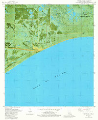
1979 Map of Cheniere Au Tigre
USGS Topo · Published 1980About this map
Cheniere au Tigre sits as an isolated coastal ridge settlement overlooking the Gulf of Mexico, characterized by its distinct ribbon of dry land amidst the surrounding marsh. This orthophotomap, based on mid-1970s imagery, reveals a landscape defined by the intersection of conservation and industry. Large tracts are dedicated to the Paul J Rainey Wildlife Sanctuary and the State Wildlife Refuge, yet the terrain is heavily marked by a network of canals and energy infrastructure. The presence of the Nicks Lake Gas Field and Freshwater Bayou Gas Field, alongside numerous Drill Holes, illustrates the extent of petroleum exploration in the Vermilion Parish wetlands. Local history and genealogy interests are centered on the small cemetery marked Cem and the settlement of Sagrera, providing a record of habitation along the cheniere before late-century environmental shifts further altered the coastline.
Find a feature on this map
17 named features on this map. Tap any name to fly to it.
Don’t see what you’re looking for? This feature index may not catch every label — zoom into the map to look around manually.
Map Details
Editions of this 1979 Cheniere Au Tigre Map
This is the sole edition of this map. No revisions or reprints were ever made.
Other maps of this area

1932 · Pecan Island SE
USGS Topo · 1:31,680

1945 · Pecan Island NE
USGS Topo · 1:31,680

1946 · Redfish Point SW
USGS Topo · 1:31,680

1946 · Redfish Point NE
USGS Topo · 1:31,680

1946 · Redfish Point SE
USGS Topo · 1:31,680

1946 · Redfish Point NW
USGS Topo · 1:31,680

1951 · Pecan Island
USGS Topo · 1:62,500

1951 · Cheniere Au Tigre
USGS Topo · 1:62,500
1954 · Redfish Point SE
USGS Topo · 1:31,680
1954 · Redfish Point NE
USGS Topo · 1:31,680