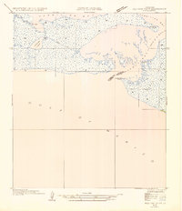
1954 Map of Redfish Point SE
USGS Topo · Published 1954About this map
Marsh Island and the coastal waters of Vermilion Bay dominate this mid-century topographic study, capturing the intricate shoreline of coastal Louisiana before significant modern changes. The landscape is defined by the critical passage of Southwest Pass, which separates the island from the mainland near the boundary of Vermilion Parish and Iberia Parish. This 1932 field examination, compiled into an advance sheet, provides rare documentation of the historic Pirogue Trail cutting through the wetlands, a detail reflecting traditional transportation methods used in the bayou long before extensive road development. To the west, Portage Lake and the colorfully named Hell Hole sit amidst a network of small inlets and marshes. Coastal navigation is anchored by named landmarks including Lighthouse Point, Southwest Point, and Porpoise Point, tracing the edge where the marsh meets the Gulf of Mexico.
Find a feature on this map
13 named features on this map. Tap any name to fly to it.
Don’t see what you’re looking for? This feature index may not catch every label — zoom into the map to look around manually.
Map Details
Editions of this 1954 Redfish Point SE Map
This is the sole edition of this map. No revisions or reprints were ever made.
Other maps of this area

1945 · New Orleans
USGS Topo · 1:250,000

1946 · Redfish Point SW
USGS Topo · 1:31,680

1946 · Redfish Point NE
USGS Topo · 1:31,680

1946 · Redfish Point SE
USGS Topo · 1:31,680

1946 · Redfish Point NW
USGS Topo · 1:31,680

1948 · Cypremort Point
USGS Topo · 1:24,000

1949 · Bayou Lucien
USGS Topo · 1:31,680
1951 · Bayou Lucien
USGS Topo · 1:24,000

1951 · Cheniere Au Tigre
USGS Topo · 1:62,500
1954 · Redfish Point NE
USGS Topo · 1:31,680