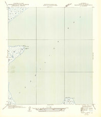
1954 Map of Redfish Point NE
USGS Topo · Published 1954About this map
Vermilion Bay dominates this coastal survey, where the low-lying marshlands of Louisiana meet the open water. The landscape is defined by its isolation and the shifting boundary between land and sea, featuring prominent points such as Red Fish Point and Indian Point. Navigational safety for the era's maritime traffic is marked by the Redfish Lighthouse, standing at the edge of the wetlands. Inland, small bodies of water like North Lake and Muddy pocket the terrain, reflecting the saturated nature of the Vermilion Parish coastline. This document captures the coastal geography prior to significant mid-century changes, based on field examinations conducted in the early 1930s.
Find a feature on this map
6 named features on this map. Tap any name to fly to it.
Don’t see what you’re looking for? This feature index may not catch every label — zoom into the map to look around manually.
Map Details
Editions of this 1954 Redfish Point NE Map
This is the sole edition of this map. No revisions or reprints were ever made.
Other maps of this area

1932 · Abbeville SW
USGS Topo · 1:31,680

1932 · Abbeville SE
USGS Topo · 1:31,680

1937 · Derouen
USGS Topo · 1:62,500

1945 · New Orleans
USGS Topo · 1:250,000

1946 · Redfish Point SW
USGS Topo · 1:31,680

1946 · Redfish Point NE
USGS Topo · 1:31,680

1946 · Redfish Point SE
USGS Topo · 1:31,680

1946 · Redfish Point NW
USGS Topo · 1:31,680

1948 · Cypremort Point
USGS Topo · 1:24,000

1949 · Bayou Lucien
USGS Topo · 1:31,680