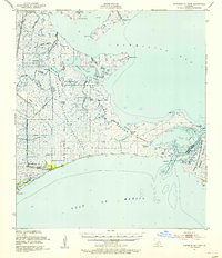
1951 Map of Cheniere Au Tigre
USGS Topo · Published 1955About this map
Cheniere au Tigre stands as the primary human settlement in this coastal marshland, situated along the Blue Ridge near the edge of the Gulf of Mexico. The landscape is a complex network of brackish water and low-lying terrain, featuring extensive conservation tracts such as the Paul J. Rainey Wildlife Sanctuary and the Russell Sage Foundation State Game Refuge. In the early 1950s, this area remained largely inaccessible by road, defined instead by maritime features like Lighthouse Point and the Pirogue Trail, the latter reflecting traditional coastal transportation through the wetlands.
Find a feature on this map
41 named features on this map. Tap any name to fly to it.
Don’t see what you’re looking for? This feature index may not catch every label — zoom into the map to look around manually.
Map Details
Editions of this 1951 Cheniere Au Tigre Map
3 editions found
Historical Maps of Cheniere au Tigre Through Time
184 maps found

1932 Abbeville NE
Vermilion Parish, LA

1932 Abbeville NW
Vermilion Parish, LA

1932 Abbeville SE
Vermilion Parish, LA

1932 Abbeville SW
Vermilion Parish, LA

1932 Constance Bayou NE
Vermilion Parish, LA

1932 Constance Bayou SE
Vermilion Parish, LA

1932 Pecan Island SE
Vermilion Parish, LA

1932 Pecan Island SW
Vermilion Parish, LA

1945 Pecan Island NE
Vermilion Parish, LA

1945 Pecan Island NW
Vermilion Parish, LA

1946 Leroy
Vermilion Parish, LA

1946 Redfish Point NE
Vermilion Parish, LA

1946 Redfish Point NW
Vermilion Parish, LA

1946 Redfish Point SE
Vermilion Parish, LA

1946 Redfish Point SW
Vermilion Parish, LA

1946 Schooner Bayou NE
Vermilion Parish, LA

1946 Schooner Bayou NW
Vermilion Parish, LA

1946 Schooner Bayou SE
Vermilion Parish, LA

1946 Schooner Bayou SW
Vermilion Parish, LA

1951 Cheniere Au Tigre
Vermilion Parish, LA

1951 Pecan Island
Vermilion Parish, LA

1953 Jacks Point Island
Vermilion Parish, LA

1954 Constance Bayou SE
Vermilion Parish, LA

1954 Grand Lake East NE
Vermilion Parish, LA

1954 Grand Lake East SE
Vermilion Parish, LA

1954 Leroy
Vermilion Parish, LA

1954 Pecan Island NE
Vermilion Parish, LA

1954 Pecan Island NW
Vermilion Parish, LA

1954 Pecan Island SE
Vermilion Parish, LA

1954 Pecan Island SW
Vermilion Parish, LA

1954 Redfish Point NE
Vermilion Parish, LA

1954 Redfish Point NW
Vermilion Parish, LA

1954 Redfish Point SE
Vermilion Parish, LA

1954 Redfish Point SW
Vermilion Parish, LA

1954 Schooner Bayou NE
Vermilion Parish, LA

1954 Schooner Bayou NW
Vermilion Parish, LA

1954 Schooner Bayou SE
Vermilion Parish, LA

1954 Schooner Bayou SW
Vermilion Parish, LA

1955 Forked Island
Vermilion Parish, LA

1975 Abbeville East
Vermilion Parish, LA

1975 Abbeville West
Vermilion Parish, LA

1975 Intracoastal City
Vermilion Parish, LA

1979 Cheniere Au Tigre
Vermilion Parish, LA

1979 Fearman Lake
Vermilion Parish, LA

1979 Floating Turf Bayou
Vermilion Parish, LA

1979 Forked Island NW
Vermilion Parish, LA

1979 Forked Island
Vermilion Parish, LA

1979 Hell Hole Bayou
Vermilion Parish, LA

1979 Kaplan South
Vermilion Parish, LA

1979 Lake Le Bleu
Vermilion Parish, LA

1979 Latanier Bayou
Vermilion Parish, LA

1979 Mulberry Island East
Vermilion Parish, LA

1979 Mulberry Island West
Vermilion Parish, LA

1979 Pecan Island
Vermilion Parish, LA

1979 Pumpkin Islands
Vermilion Parish, LA

1979 Redfish Point
Vermilion Parish, LA

1979 Rollover Lake
Vermilion Parish, LA

1983 Kaplan North
Vermilion Parish, LA

1983 Leroy
Vermilion Parish, LA

1983 White Lake
Vermilion Parish, LA

1983 Wright
Vermilion Parish, LA

1994 Abbeville East
Vermilion Parish, LA

1994 Abbeville West
Vermilion Parish, LA

1998 Hell Hole Bayou
Vermilion Parish, LA

2012 Abbeville East
Vermilion Parish, LA

2012 Abbeville West
Vermilion Parish, LA

2012 Cheniere au Tigre
Vermilion Parish, LA

2012 Fearman Lake
Vermilion Parish, LA

2012 Floating Turf Bayou
Vermilion Parish, LA

2012 Forked Island NW
Vermilion Parish, LA

2012 Forked Island
Vermilion Parish, LA

2012 Hebert Lake
Vermilion Parish, LA

2012 Hell Hole Bayou
Vermilion Parish, LA

2012 Intracoastal City
Vermilion Parish, LA

2012 Jacks Point Island
Vermilion Parish, LA

2012 Kaplan North
Vermilion Parish, LA

2012 Kaplan South
Vermilion Parish, LA

2012 Lake Le Bleu
Vermilion Parish, LA

2012 Latanier Bayou
Vermilion Parish, LA

2012 Leroy
Vermilion Parish, LA

2012 Mulberry Island East
Vermilion Parish, LA

2012 Mulberry Island West
Vermilion Parish, LA

2012 Pecan Island
Vermilion Parish, LA

2012 Pumpkin Islands
Vermilion Parish, LA

2012 Redfish Point
Vermilion Parish, LA

2012 Rollover Lake
Vermilion Parish, LA

2012 Wright
Vermilion Parish, LA

2015 Abbeville East
Vermilion Parish, LA

2015 Abbeville West
Vermilion Parish, LA

2015 Cheniere au Tigre
Vermilion Parish, LA

2015 Fearman Lake
Vermilion Parish, LA

2015 Floating Turf Bayou
Vermilion Parish, LA

2015 Forked Island NW
Vermilion Parish, LA

2015 Forked Island
Vermilion Parish, LA

2015 Hebert Lake
Vermilion Parish, LA

2015 Hell Hole Bayou
Vermilion Parish, LA

2015 Intracoastal City
Vermilion Parish, LA

2015 Jacks Point Island
Vermilion Parish, LA

2015 Kaplan North
Vermilion Parish, LA

2015 Kaplan South
Vermilion Parish, LA

2015 Lake Le Bleu
Vermilion Parish, LA

2015 Latanier Bayou
Vermilion Parish, LA

2015 Leroy
Vermilion Parish, LA

2015 Mulberry Island East
Vermilion Parish, LA

2015 Mulberry Island West
Vermilion Parish, LA

2015 Pecan Island
Vermilion Parish, LA

2015 Pumpkin Islands
Vermilion Parish, LA

2015 Redfish Point
Vermilion Parish, LA

2015 Rollover Lake
Vermilion Parish, LA

2015 Wright
Vermilion Parish, LA

2018 Abbeville East
Vermilion Parish, LA

2018 Abbeville West
Vermilion Parish, LA

2018 Cheniere au Tigre
Vermilion Parish, LA

2018 Fearman Lake
Vermilion Parish, LA

2018 Floating Turf Bayou
Vermilion Parish, LA

2018 Forked Island NW
Vermilion Parish, LA

2018 Forked Island
Vermilion Parish, LA

2018 Hebert Lake
Vermilion Parish, LA

2018 Hell Hole Bayou
Vermilion Parish, LA

2018 Intracoastal City
Vermilion Parish, LA

2018 Jacks Point Island
Vermilion Parish, LA

2018 Kaplan North
Vermilion Parish, LA

2018 Kaplan South
Vermilion Parish, LA

2018 Lake Le Bleu
Vermilion Parish, LA

2018 Latanier Bayou
Vermilion Parish, LA

2018 Leroy
Vermilion Parish, LA

2018 Mulberry Island East
Vermilion Parish, LA

2018 Mulberry Island West
Vermilion Parish, LA

2018 Pecan Island
Vermilion Parish, LA

2018 Pumpkin Islands
Vermilion Parish, LA

2018 Redfish Point
Vermilion Parish, LA

2018 Rollover Lake
Vermilion Parish, LA

2018 Wright
Vermilion Parish, LA

2020 Abbeville East
Vermilion Parish, LA

2020 Abbeville West
Vermilion Parish, LA

2020 Cheniere au Tigre
Vermilion Parish, LA

2020 Fearman Lake
Vermilion Parish, LA

2020 Floating Turf Bayou
Vermilion Parish, LA

2020 Forked Island NW
Vermilion Parish, LA

2020 Forked Island
Vermilion Parish, LA

2020 Hebert Lake
Vermilion Parish, LA

2020 Hell Hole Bayou
Vermilion Parish, LA

2020 Intracoastal City
Vermilion Parish, LA

2020 Jacks Point Island
Vermilion Parish, LA

2020 Kaplan North
Vermilion Parish, LA

2020 Kaplan South
Vermilion Parish, LA

2020 Lake Le Bleu
Vermilion Parish, LA

2020 Latanier Bayou
Vermilion Parish, LA

2020 Leroy
Vermilion Parish, LA

2020 Mulberry Island East
Vermilion Parish, LA

2020 Mulberry Island West
Vermilion Parish, LA

2020 Pecan Island
Vermilion Parish, LA

2020 Pumpkin Islands
Vermilion Parish, LA

2020 Redfish Point
Vermilion Parish, LA

2020 Rollover Lake
Vermilion Parish, LA

2020 Wright
Vermilion Parish, LA

2024 Abbeville East
Vermilion Parish, LA

2024 Abbeville West
Vermilion Parish, LA

2024 Cheniere au Tigre
Vermilion Parish, LA

2024 Fearman Lake
Vermilion Parish, LA

2024 Floating Turf Bayou
Vermilion Parish, LA

2024 Forked Island NW
Vermilion Parish, LA

2024 Forked Island
Vermilion Parish, LA

2024 Hebert Lake
Vermilion Parish, LA

2024 Hell Hole Bayou
Vermilion Parish, LA

2024 Intracoastal City
Vermilion Parish, LA

2024 Jacks Point Island
Vermilion Parish, LA

2024 Kaplan North
Vermilion Parish, LA

2024 Kaplan South
Vermilion Parish, LA

2024 Lake Le Bleu
Vermilion Parish, LA

2024 Latanier Bayou
Vermilion Parish, LA

2024 Leroy
Vermilion Parish, LA

2024 Mulberry Island East
Vermilion Parish, LA

2024 Mulberry Island West
Vermilion Parish, LA

2024 Pecan Island
Vermilion Parish, LA

2024 Pumpkin Islands
Vermilion Parish, LA

2024 Redfish Point
Vermilion Parish, LA

2024 Rollover Lake
Vermilion Parish, LA

2024 Wright
Vermilion Parish, LA

2025 Cheniere au Tigre
Vermilion Parish, LA

2025 Hell Hole Bayou
Vermilion Parish, LA

2025 Mulberry Island East
Vermilion Parish, LA

2025 Mulberry Island West
Vermilion Parish, LA

2025 Rollover Lake
Vermilion Parish, LA