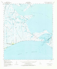
1951 Map of Cheniere Au Tigre
USGS Topo · Published 1974About this map
Cheniere au Tigre stands as a distinct coastal settlement along the Gulf of Mexico, defined by its remote location at the edge of Bill Ridge. In the early 1950s, this landscape was dominated by expansive wetlands and protective reserves, including the Paul J Rainey Wildlife Sanctuary and the State Game Refuge. The intricate network of waterways like Fearman Lake and Southwest Pass illustrates the coastal transition where the Vermilion Bay meets the open sea. Human activity in this marshy environment is evidenced by the Pirogue Trail and landmarks like Lighthouse Point, reflecting an era focused on conservation and maritime navigation. The presence of a Cem near the coast hints at the long-standing community ties to this isolated ridge, while named features such as Deadman Island and Hell Hole speak to the challenging character of the Louisiana wetlands before modern development shifted the coastline.
Find a feature on this map
49 named features on this map. Tap any name to fly to it.
Don’t see what you’re looking for? This feature index may not catch every label — zoom into the map to look around manually.
Map Details
Editions of this 1951 Cheniere Au Tigre Map
3 editions found

Other maps of this area

1932 · Abbeville SW
USGS Topo · 1:31,680

1932 · Abbeville SE
USGS Topo · 1:31,680

1932 · Pecan Island SE
USGS Topo · 1:31,680

1937 · Derouen
USGS Topo · 1:62,500

1945 · New Orleans
USGS Topo · 1:250,000

1945 · Pecan Island NE
USGS Topo · 1:31,680

1946 · Redfish Point SW
USGS Topo · 1:31,680

1946 · Schooner Bayou SE
USGS Topo · 1:31,680

1946 · Redfish Point NE
USGS Topo · 1:31,680

1946 · Redfish Point SE
USGS Topo · 1:31,680