1940s Maps of Stein, Louisiana
Explore 1 historic maps of Stein from the 1940s. These maps offer a rare glimpse into what life looked like during the 1940s — showing old roads, neighborhoods, homes, and landmarks that have changed or disappeared over time.
Whether you're researching your family's past, planning a metal detecting trip, or studying how Stein's landscape evolved across the 1940s, these high-resolution maps are a powerful tool for exploring the history of this region.
- Focus on a specific era: All maps on this page are from the 1940s, giving you a focused view of this time period.
- See what’s changed: Compare century-old streets, trails, and buildings to today's modern landscape using overlays and satellite layers.
- Research with precision: Use these maps for genealogy, historical research, land use analysis, or educational projects.
- View, download, or print: Maps are fully viewable online in high resolution, and can be downloaded or printed for your own records.
Start exploring Stein's history through authentic maps from the 1940s. This is your window into the past.
Stein, LA maps
(1)- 1942 Map of Rio
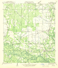 1942 Rio1942 Print · USGSThe borderlands of Washington and St. Tammany Parishes are captured here in the early 1940s as the Bogue Chitto River winds through the southern woods. Researchers can locate many family-named landmarks including the Old Magee Cem, Rosenwald Sch, and the rail stop at Rio.
End of results
Showing maps 1-1 of 1
Top cities near Stein
- Bogalusa historical maps
- Picayune historical maps
- Covington historical maps
- Franklinton historical maps
- Abita Springs historical maps
- Sun historical maps
See more
Frequently asked questions
- What are the different types of historical maps available for Stein?
- What is the oldest map of Stein?
- Where can I purchase historical maps of Stein for my home or office?
- Where can I download high-res historical maps of Stein?
- Are there historical topographic maps available for Stein?
- Is there historical aerial imagery available for Stein?
- Where are historical maps of Stein sourced from?