1930s Maps of Portage Lake, Maine
Explore 6 historic maps of Portage Lake from the 1930s. These maps offer a rare glimpse into what life looked like during the 1930s — showing old roads, neighborhoods, homes, and landmarks that have changed or disappeared over time.
Whether you're researching your family's past, planning a metal detecting trip, or studying how Portage Lake's landscape evolved across the 1930s, these high-resolution maps are a powerful tool for exploring the history of this region.
- Focus on a specific era: All maps on this page are from the 1930s, giving you a focused view of this time period.
- See what’s changed: Compare century-old streets, trails, and buildings to today's modern landscape using overlays and satellite layers.
- Research with precision: Use these maps for genealogy, historical research, land use analysis, or educational projects.
- View, download, or print: Maps are fully viewable online in high resolution, and can be downloaded or printed for your own records.
Start exploring Portage Lake's history through authentic maps from the 1930s. This is your window into the past.
Portage Lake, ME maps
(6)- 1930 Map of Greenlaw
 1930 Greenlaw1930 Print · USGSAroostook County was a hub of timber and rail activity in the early thirties, defined by remote camps and a developing backcountry road network. Genealogists and historians can trace old routes like the Old Military Road and locate sites such as Seven Mile Camp and Greenlaw Crossing.5 unique versions available
 - 1931 Map of Ashland
 1931 Ashland1931 Print · USGSAroostook County logging and rail life are detailed here in the early 1930s, centered on the Ashland and Sheridan settlements. Researchers can trace rural school districts from McClellan Sch to Garfield Sch or locate industrial sites like Newlands Mill and the Squapan Dam.
 - 1931 Map of Portage
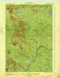
 1931 Portage1931 Print · USGSAroostook County's deep woods and logging heritage are preserved here as they appeared between the wars, from the shores of Portage Lake to the remote camps of Westmanland. Researchers can trace the early rail network of the Bangor and Aroostook or locate industrial sites like the Old Shingle Mill.3 unique versions available
 - 1931 Map of Winterville
 1931 Winterville1931 Print · USGSThe North Woods of Maine are seen here in the early 1930s, when logging camps and the railroad were the primary lifelines of the region. Local historians can trace family-named sites like McNally and Nixon or locate isolated structures like T 15 R 6 Sch.4 unique versions available
 - 1933 Map of Greenlaw
 1933 Greenlaw1933 Print · USGSAroostook County’s timberlands are shown here in the early 1930s, when river landings and remote sporting camps defined the deep woods. Researchers can trace historic logging routes like the Old Military Road and locate vanished outposts such as Orcutts Camp and The Owls Roost.3 unique versions available
 - 1934 Map of Ashland
 1934 Ashland1934 Print · USGSAroostook County's timber and rail heritage is on full display in the 1930s, centered on the confluence of the Aroostook River and Bangor and Aroostook line. Genealogists can locate family schoolhouses like Rockwell Sch and early industrial sites such as Nowland Mill.3 unique versions available
End of results
Showing maps 1-6 of 6
Top cities near Portage Lake
- Ashland historical maps
- Eagle Lake historical maps
- Castle Hill historical maps
- Perham historical maps
- Wade historical maps
- Winterville Plantation historical maps
See more
Top neighborhoods of Portage Lake
Frequently asked questions
- What are the different types of historical maps available for Portage Lake?
- What is the oldest map of Portage Lake?
- Where can I purchase historical maps of Portage Lake for my home or office?
- Where can I download high-res historical maps of Portage Lake?
- Are there historical topographic maps available for Portage Lake?
- Is there historical aerial imagery available for Portage Lake?
- Where are historical maps of Portage Lake sourced from?