1980s Maps of Portage Lake, Maine
Explore 4 historic maps of Portage Lake from the 1980s. These maps offer a rare glimpse into what life looked like during the 1980s — showing old roads, neighborhoods, homes, and landmarks that have changed or disappeared over time.
Whether you're researching your family's past, planning a metal detecting trip, or studying how Portage Lake's landscape evolved across the 1980s, these high-resolution maps are a powerful tool for exploring the history of this region.
- Focus on a specific era: All maps on this page are from the 1980s, giving you a focused view of this time period.
- See what’s changed: Compare century-old streets, trails, and buildings to today's modern landscape using overlays and satellite layers.
- Research with precision: Use these maps for genealogy, historical research, land use analysis, or educational projects.
- View, download, or print: Maps are fully viewable online in high resolution, and can be downloaded or printed for your own records.
Start exploring Portage Lake's history through authentic maps from the 1980s. This is your window into the past.
Portage Lake, ME maps
(4)- 1986 Map of Portage Lake East
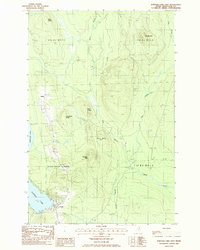 1986 Portage Lake East1986 Print · USGSNorthern Maine timber country comes into focus in the mid-eighties, centered on the lakeside settlement of Portage. Researchers can trace the Bangor and Aroostook rail line, local landmarks like Lanigan Mtn, and the small community at Buffalo.
 - 1986 Map of Portage Lake West
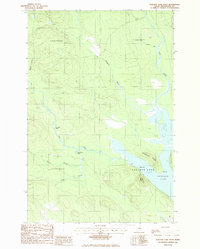 1986 Portage Lake West1986 Print · USGSAroostook County's wild interior is captured here in the mid-1980s, centered on the expansive Portage Lake. Outdoor historians and researchers can trace the serpentine Fish River past Big Pine Bend and locate remote landmarks like West Mtn.
 - 1986 Map of Little Machias Lake
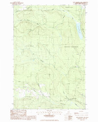 1986 Little Machias Lake1986 Print · USGSAroostook County timberlands are mapped here in the mid-1980s, showcasing the remote township system and logging networks. Researchers can trace historic drainage paths and access points through Nashville Plantation and along Little Machias Lake.
 - 1986 Map of Ashland
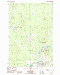 1986 Ashland1986 Print · USGSAshland and the river valleys of northern Maine are captured here in the mid-eighties as timber and local industry shaped the landscape. Genealogists and historians can trace the residents of Sheridan, Skerry, and the riverfront lots along the Old RR Grade.
End of results
Showing maps 1-4 of 4
Top cities near Portage Lake
- Ashland historical maps
- Eagle Lake historical maps
- Castle Hill historical maps
- Perham historical maps
- Wade historical maps
- Winterville Plantation historical maps
See more
Top neighborhoods of Portage Lake
Frequently asked questions
- What are the different types of historical maps available for Portage Lake?
- What is the oldest map of Portage Lake?
- Where can I purchase historical maps of Portage Lake for my home or office?
- Where can I download high-res historical maps of Portage Lake?
- Are there historical topographic maps available for Portage Lake?
- Is there historical aerial imagery available for Portage Lake?
- Where are historical maps of Portage Lake sourced from?