1980s Maps of T10 R6 WELS, Maine
Explore 5 historic maps of T10 R6 WELS from the 1980s. These maps offer a rare glimpse into what life looked like during the 1980s — showing old roads, neighborhoods, homes, and landmarks that have changed or disappeared over time.
Whether you're researching your family's past, planning a metal detecting trip, or studying how T10 R6 WELS's landscape evolved across the 1980s, these high-resolution maps are a powerful tool for exploring the history of this region.
- Focus on a specific era: All maps on this page are from the 1980s, giving you a focused view of this time period.
- See what’s changed: Compare century-old streets, trails, and buildings to today's modern landscape using overlays and satellite layers.
- Research with precision: Use these maps for genealogy, historical research, land use analysis, or educational projects.
- View, download, or print: Maps are fully viewable online in high resolution, and can be downloaded or printed for your own records.
Start exploring T10 R6 WELS's history through authentic maps from the 1980s. This is your window into the past.
T10 R6 WELS, ME maps
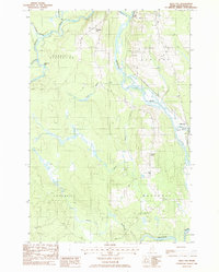
(5)- 1985 Map of Oakfield
 1985 Oakfield1985 Print · USGSAroostook County in the 1980s displays a balance between the timber-and-rail industry and the protected wilderness of the North Woods. Genealogists and local historians can trace family-named hubs like Smyrna Mills, Island Falls, and Knowles Corner along the Bangor and Aroostook railroad line.
 - 1986 Map of Squa Pan
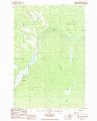
 1986 Squa Pan1986 Print · USGSAroostook County was a landscape of timber and intersecting rivers during the mid-eighties, centered on the junction of the Machias River and Aroostook River. Genealogists and local historians can trace the borders of Garfield Plantation and find landmarks like the Town Hall and Squa Pan settlement.
 - 1986 Map of Forks of Machias
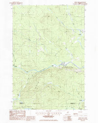
 1986 Forks of Machias1986 Print · USGSAroostook County's remote timberlands are captured here in the mid-1980s, centered on the winding Machias River and its many tributaries. Researchers can locate isolated landmarks like V E Lynch Camp, the Forks of Machias, and Grassy Landing.
 - 1986 Map of Oxbow West
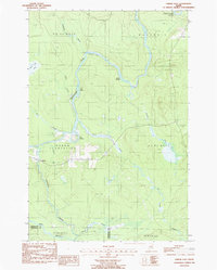
 1986 Oxbow West1986 Print · USGSMaine's North Woods are captured here in the mid-1980s, centered on the river-driven landscape of Oxbow Plantation. Genealogists and researchers can locate remote outposts like Junkins Camp, trace the Aroostook River, and identify landmarks such as Old Maid Rock.
 - 1986 Map of Oxbow East, 1987 Print
 1986 Oxbow East1987 Print · USGSIn the mid-1980s, the Aroostook River valley remained a landscape of timber tracts and small plantations. Genealogists and historians can trace the local infrastructure of Oxbow Plantation, finding the Cem. and settlements like Oxbow and Aikens.
End of results
Showing maps 1-5 of 5
Top cities near T10 R6 WELS
- Ashland historical maps
- Castle Hill historical maps
- Masardis historical maps
- Garfield Plantation historical maps
- Oxbow historical maps
- Nashville Plantation historical maps
Frequently asked questions
- What are the different types of historical maps available for T10 R6 WELS?
- What is the oldest map of T10 R6 WELS?
- Where can I purchase historical maps of T10 R6 WELS for my home or office?
- Where can I download high-res historical maps of T10 R6 WELS?
- Are there historical topographic maps available for T10 R6 WELS?
- Is there historical aerial imagery available for T10 R6 WELS?
- Where are historical maps of T10 R6 WELS sourced from?