1980s Maps of T11 R4 WELS, Maine
Explore 4 historic maps of T11 R4 WELS from the 1980s. These maps offer a rare glimpse into what life looked like during the 1980s — showing old roads, neighborhoods, homes, and landmarks that have changed or disappeared over time.
Whether you're researching your family's past, planning a metal detecting trip, or studying how T11 R4 WELS's landscape evolved across the 1980s, these high-resolution maps are a powerful tool for exploring the history of this region.
- Focus on a specific era: All maps on this page are from the 1980s, giving you a focused view of this time period.
- See what’s changed: Compare century-old streets, trails, and buildings to today's modern landscape using overlays and satellite layers.
- Research with precision: Use these maps for genealogy, historical research, land use analysis, or educational projects.
- View, download, or print: Maps are fully viewable online in high resolution, and can be downloaded or printed for your own records.
Start exploring T11 R4 WELS's history through authentic maps from the 1980s. This is your window into the past.
T11 R4 WELS, ME maps
(4)- 1984 Map of Mapleton
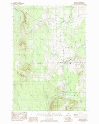 1984 Mapleton1984 Print · USGSMid-century Aroostook County comes to life as a landscape of timber and rail where the Aroostook River meets the hills. Genealogists and historians can trace the Bangor and Aroostook railroad line through Mapleton and Chapman, or locate family sites near Castle Hill Cem.
 - 1984 Map of Squa Pan Lake East
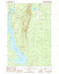 1984 Squa Pan Lake East1984 Print · USGSAroostook County's timber and rail landscape is well-preserved here in the early 1980s, centered on the heights of Squa Pan Mountain. Local historians can trace the Bangor and Aroostook railroad past Walker and identify old shore sites like Husdn Landing.
 - 1986 Map of Squa Pan Lake West
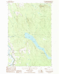 1986 Squa Pan Lake West1986 Print · USGSNorthern Maine's timber and water country comes into focus in the mid-1980s, centered on the settlement of Masardis. Researchers can trace the hydroelectric infrastructure around Squa Pan Lake, including the Powerhouse and its connection to the Aroostook River.
 - 1986 Map of York Ridge
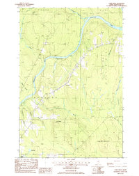 1986 York Ridge1986 Print · USGSThe Aroostook County woods come into focus during the mid-eighties as a landscape of timberlands and river valleys. Researchers can trace rural landmarks like the Cem near Frenchville, the heights of York Ridge, and the path of the Aroostook River.
End of results
Showing maps 1-4 of 4
Top cities near T11 R4 WELS
- Presque Isle historical maps
- Caribou historical maps
- Mapleton historical maps
- Washburn historical maps
- Ashland historical maps
- Chapman historical maps
See more
Top neighborhoods of T11 R4 WELS
Frequently asked questions
- What are the different types of historical maps available for T11 R4 WELS?
- What is the oldest map of T11 R4 WELS?
- Where can I purchase historical maps of T11 R4 WELS for my home or office?
- Where can I download high-res historical maps of T11 R4 WELS?
- Are there historical topographic maps available for T11 R4 WELS?
- Is there historical aerial imagery available for T11 R4 WELS?
- Where are historical maps of T11 R4 WELS sourced from?