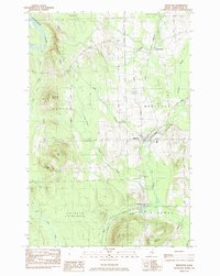
1984 Map of Mapleton
USGS Topo · Published 1984About this map
The Aroostook River winds through the northern reaches of this central Aroostook County landscape, defining a region where timberlands and agriculture meet. The village of Mapleton serves as a primary hub, situated near the intersection of the Bangor and Aroostook railroad and the Presque Isle Stream. The terrain is punctuated by significant elevations such as Haystack Mtn, Pyle Mtn, and McDonald Mtn, which rise above the surrounding valleys of Libby Brook and Dudley Swamp.
Find a feature on this map
34 named features on this map. Tap any name to fly to it.
Don’t see what you’re looking for? This feature index may not catch every label — zoom into the map to look around manually.
Map Details
Editions of this 1984 Mapleton Map
This is the sole edition of this map. No revisions or reprints were ever made.
Other maps of this area

1929 · Portage
USGS Topo · 1:62,500

1929 · Caribou
USGS Topo · 1:48,000

1931 · Ashland
USGS Topo · 1:48,000

1931 · Portage
USGS Topo · 1:62,500

1932 · Caribou
USGS Topo · 1:62,500

1934 · Ashland
USGS Topo · 1:62,500

1935 · Presque Isle
USGS Topo · 1:62,500

1953 · Ashland
USGS Topo · 1:62,500

1953 · Portage
USGS Topo · 1:62,500

1953 · Presque Isle
USGS Topo · 1:62,500