1970s Maps of T14 R9 WELS, Maine
Explore 4 historic maps of T14 R9 WELS from the 1970s. These maps offer a rare glimpse into what life looked like during the 1970s — showing old roads, neighborhoods, homes, and landmarks that have changed or disappeared over time.
Whether you're researching your family's past, planning a metal detecting trip, or studying how T14 R9 WELS's landscape evolved across the 1970s, these high-resolution maps are a powerful tool for exploring the history of this region.
- Focus on a specific era: All maps on this page are from the 1970s, giving you a focused view of this time period.
- See what’s changed: Compare century-old streets, trails, and buildings to today's modern landscape using overlays and satellite layers.
- Research with precision: Use these maps for genealogy, historical research, land use analysis, or educational projects.
- View, download, or print: Maps are fully viewable online in high resolution, and can be downloaded or printed for your own records.
Start exploring T14 R9 WELS's history through authentic maps from the 1970s. This is your window into the past.
T14 R9 WELS, ME maps
(4)- 1975 Map of Fish River Lake SW, 1981 Print
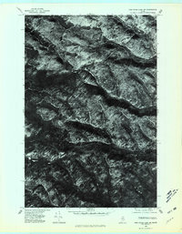 1975 Fish River Lake SW1981 Print · USGSRemote Maine timberlands are captured in high detail during the mid-seventies, showing the vast forest canopy and logging network. Trace the winding paths of North Branch Fox Brook and South Branch Fox Brook through the woods.
 - 1975 Map of Fish River Lake NE, 1981 Print
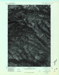 1975 Fish River Lake NE1981 Print · USGSNorthern Maine forestlands are captured in high detail in the mid-1970s, showcasing the remote wilderness of Aroostook County. Researchers can trace the drainages of Red River and Rocky Brook or locate high-elevation water bodies like Deboullie Pond.
 - 1975 Map of Fish River Lake NW, 1981 Print
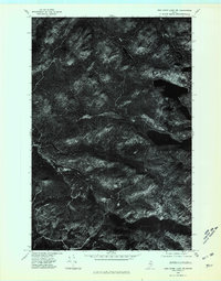 1975 Fish River Lake NW1981 Print · USGSThe North Maine Woods are captured in this mid-1970s aerial survey, showing the wilderness surrounding Deboullie Mountain. Researchers can trace the timbered ridges and secluded shores of Fish River Lake and Mud Pond.
 - 1975 Map of Fish River Lake SE, 1981 Print
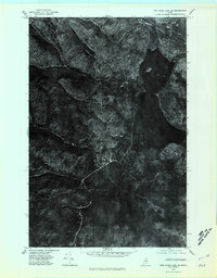 1975 Fish River Lake SE1981 Print · USGSThe deep woods of Aroostook County are revealed in this mid-seventies orthophoto, showing the Maine timberlands just as they were. Trace the undisturbed shorelines of Fish Lake and follow the paths of Chase Brook and Fox Brook through the forest.
End of results
Showing maps 1-4 of 4
Top cities near T14 R9 WELS
- Eagle Lake historical maps
- Wallagrass historical maps
- Saint Francis historical maps
- Saint John Plantation historical maps
- Allagash historical maps
- Winterville Plantation historical maps
Frequently asked questions
- What are the different types of historical maps available for T14 R9 WELS?
- What is the oldest map of T14 R9 WELS?
- Where can I purchase historical maps of T14 R9 WELS for my home or office?
- Where can I download high-res historical maps of T14 R9 WELS?
- Are there historical topographic maps available for T14 R9 WELS?
- Is there historical aerial imagery available for T14 R9 WELS?
- Where are historical maps of T14 R9 WELS sourced from?