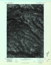
1975 Map of Fish River Lake NE
USGS Topo · Published 1981About this map
Deboullie Pond and Black Pond dominate the high northwestern terrain of this orthophotoquad, where the landscape is defined by the sharp relief of northern Maine's forestlands. Captured in late 1975, the imagery reveals the timber-rich topography surrounding Whitman Mountain and Black Mountain. This map provides a clear look at the drainage patterns of the era, showing the paths of the Red River, Rocky Brook, and Chase Brook as they cut through the dense canopy. Unlike traditional topographic maps, this orthophoto uses rectified aerial photography to show the actual surface conditions of the wilderness, including old logging access paths and forest clearings that were present during the mid-1970s. It is a precise record of this undeveloped stretch of Aroostook County before modern forest management altered these specific timber stands.
Find a feature on this map
7 named features on this map. Tap any name to fly to it.
Don’t see what you’re looking for? This feature index may not catch every label — zoom into the map to look around manually.
Map Details
Editions of this 1975 Fish River Lake NE Map
This is the sole edition of this map. No revisions or reprints were ever made.
Other maps of this area

1928 · Eagle Lake
USGS Topo · 1:48,000

1928 · Winterville
USGS Topo · 1:48,000

1930 · St Francis
USGS Topo · 1:48,000

1931 · Fish River Lake
USGS Topo · 1:48,000

1931 · Eagle Lake
USGS Topo · 1:62,500

1931 · Winterville
USGS Topo · 1:62,500

1933 · St Francis
USGS Topo · 1:62,500

1935 · Fish River Lake
USGS Topo · 1:62,500

1954 · Presque Isle
USGS Topo · 1:250,000

1958 · Presque Isle
USGS Topo · 1:250,000