1990s Maps of Franklin County, Maine
Explore 17 historic maps of Franklin County from the 1990s. These maps offer a rare glimpse into what life looked like during the 1990s — showing old roads, neighborhoods, homes, and landmarks that have changed or disappeared over time.
Whether you're researching your family's past, planning a metal detecting trip, or studying how Franklin County's landscape evolved across the 1990s, these high-resolution maps are a powerful tool for exploring the history of this region.
- Focus on a specific era: All maps on this page are from the 1990s, giving you a focused view of this time period.
- See what’s changed: Compare century-old streets, trails, and buildings to today's modern landscape using overlays and satellite layers.
- Research with precision: Use these maps for genealogy, historical research, land use analysis, or educational projects.
- View, download, or print: Maps are fully viewable online in high resolution, and can be downloaded or printed for your own records.
Start exploring Franklin County's history through authentic maps from the 1990s. This is your window into the past.
Franklin County, ME maps
(17)- 1990 Map of Little Kennebago Lake
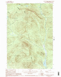 1990 Little Kennebago Lake1990 Print · USGSThe Maine-Quebec borderlands are captured here in the late twentieth century, showing the remote township system and high-country divides. Trace the rugged terrain of the White Cap Divide and search for landmarks like Little Kennebago Lake and Snow Mountain.2 unique versions available
 - 1990 Map of Northwest Pond
 1990 Northwest Pond1990 Print · USGSThe Maine-Quebec borderlands appear in high detail during the 1990s, revealing a landscape of high summits and remote glacial basins. Researchers can trace the international boundary line past Mont Gosford and locate historical landmarks like Massachusetts Bog and Seven Ponds.
 - 1990 Map of Louise Mountain
 1990 Louise Mountain1990 Print · USGSThe international boundary between Maine and Quebec is captured here in the late twentieth century, showing the remote border crossing at Coburn Gore. Researchers can trace the timber-based economy through labels like Scierie and locate historic points around Arnold Pond and Lac aux Araignées.
 - 1990 Map of Kennebago
 1990 Kennebago1990 Print · USGSNorthwestern Maine's timberlands and remote waters are captured here in the 1990s as they transitioned into the modern era. You can trace the rugged network of logging roads and fly-fishing waters near Grants Camps, Kennebago Lake, and the former Moochers Home (Site).
 - 1994 Map of Rumford
 1994 Rumford1994 Print · USGSWestern Maine's mountains and glacial lakes are shown here in the mid-1990s, from the peaks of the Mahoosuc Range to the banks of the Androscoggin River. Trace the Maine Central RR through Dixfield or locate lakeside settlements like Oquossoc.
 - 1994 Map of Megantic
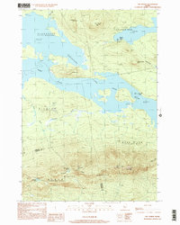
 1994 Megantic1994 Print · USGSUpper Somerset County during the early 1990s shows a landscape of remote timber outposts and the Canadian Pacific railroad. Genealogists and historians can trace the corridor through Jackman and Dennistown or locate old rail points like Skinner and Lowelltown.
 - 1994 Map of Flagstaff Lake
 1994 Flagstaff Lake1994 Print · USGSThe Maine wilderness and the Quebec border come alive in this mid-nineties survey of the Dead River country. Researchers can trace the Appalachian Trail over Bigelow Mountain and locate remote sites like Kennebago Settlement.
 - 1997 Map of Oquossoc, 1999 Print
 1997 Oquossoc1999 Print · USGSThe Rangeley Lakes region is captured here in the late twentieth century, showing the intricate shorelines and sporting camps of the Maine woods. Trace the historic Rangeley Grade or locate remote waterfront sites like Pleasant Island, Upper Dam, and the Oquossoc Angling Assn.
 - 1997 Map of Houghton, 1999 Print
 1997 Houghton1999 Print · USGSThe Maine backcountry near Byron and Rangeley Plantation is captured here in the late twentieth century, showing a landscape shaped by water and timber. Researchers can trace the Old Railroad Grade past Angel Falls or follow the Appalachian National Scenic Trail over Bemis Mtn.
 - 1997 Map of Metallak Mtn, 1999 Print
 1997 Metallak Mtn1999 Print · USGSThe high ridges of Oxford County and the deep waters of the Rangeley Lakes are captured here in the late twentieth century. Hikers and historians can trace the Appalachian National Scenic Trail as it crosses Bemis Mountain near Metallak Pond.
 - 1997 Map of Rangeley, 1999 Print
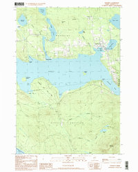 1997 Rangeley1999 Print · USGSRangeley and its surrounding plantations are captured in the late 1990s as the lakeside community continued its growth. Genealogists and researchers can trace local landmarks from Mingo Springs to the town Cem and the borders of Rangeley Lake State Park.
 - 1997 Map of Saddleback Mountain, 1999 Print
 1997 Saddleback Mountain1999 Print · USGSFranklin County's high peaks and timber plantations are captured in the late 1990s as the region's wilderness character remained firmly intact. Hikers and historians can trace the Appalachian Trail over Saddleback Mtn or locate the Old RR Grade and secluded Cem in Dallas Plantation.
 - 1997 Map of Sugarloaf Mtn, 2000 Print
 1997 Sugarloaf Mtn2000 Print · USGSMaine’s High Peaks region in the late nineties is defined by the rise of mountain recreation and the winding path of the Appalachian National Scenic Trail. Trace the early development of Carrabassett Valley and the landmarks around Sugarloaf Mtn and Stratton.
 - 1997 Map of Kennebago, 2000 Print
 1997 Kennebago2000 Print · USGSMaine's north woods near the New Hampshire border remain a wilderness of sporting camps and timberlands in the late nineties. Researchers can locate remote outposts like Grants Camps, trace the Kennebago River, and find landmarks like the Lookout Tower on West Kennebago Mountain.
 - 1997 Map of Kennebago Lake, 2000 Print
 1997 Kennebago Lake2000 Print · USGSMaine's northwestern highlands near the turn of the millennium are captured here, centered on the historic sporting traditions of Kennebago Lake. Outdoorsmen and researchers can trace the locations of Grants Camps and Kennebago Lake Camps or locate small interior waters like Ben Gile Pond.
 - 1997 Map of Stratton, 2000 Print
 1997 Stratton2000 Print · USGSThe northern Maine woods near the close of the century are defined here by the great expanse of Flagstaff Lake. Local historians can trace the settlement footprints of Stratton and Eustis or locate remote camps near Jim Pond and Cranberry Peak.
 - 1997 Map of The Horns, 2000 Print
 1997 The Horns2000 Print · USGSHigh peaks and deep waters define this corner of Somerset County in the late nineties. Hikers and historians can trace the Appalachian National Scenic Trail across The Horns and Avery Peak overlooking the expansive Flagstaff Lake.
End of results
Showing maps 1-17 of 17
Top cities of Franklin County
- Farmington historical maps
- Jay historical maps
- Wilton historical maps
- New Sharon historical maps
- Chesterville historical maps
- Rangeley historical maps
See more
Frequently asked questions
- What are the different types of historical maps available for Franklin County?
- What is the oldest map of Franklin County?
- Where can I purchase historical maps of Franklin County for my home or office?
- Where can I download high-res historical maps of Franklin County?
- Are there historical topographic maps available for Franklin County?
- Is there historical aerial imagery available for Franklin County?
- Where are historical maps of Franklin County sourced from?