1950s Maps of Franklin County, Maine
Explore 12 historic maps of Franklin County from the 1950s. These maps offer a rare glimpse into what life looked like during the 1950s — showing old roads, neighborhoods, homes, and landmarks that have changed or disappeared over time.
Whether you're researching your family's past, planning a metal detecting trip, or studying how Franklin County's landscape evolved across the 1950s, these high-resolution maps are a powerful tool for exploring the history of this region.
- Focus on a specific era: All maps on this page are from the 1950s, giving you a focused view of this time period.
- See what’s changed: Compare century-old streets, trails, and buildings to today's modern landscape using overlays and satellite layers.
- Research with precision: Use these maps for genealogy, historical research, land use analysis, or educational projects.
- View, download, or print: Maps are fully viewable online in high resolution, and can be downloaded or printed for your own records.
Start exploring Franklin County's history through authentic maps from the 1950s. This is your window into the past.
Franklin County, ME maps
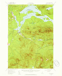
(12)- 1950 Map of Cupsuptic
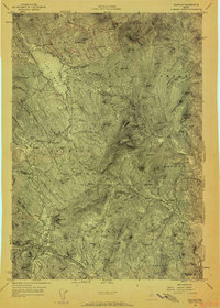
 1950 Cupsuptic1950 Print · USGSThe northern Maine woods come alive in this mid-century survey of the remote townships near the Canadian border. Researchers can trace the heritage of historic logging and sporting sites like the Parmachenee Club, Moochers Home, and Riverside Camp.
 - 1950 Map of Lewiston
 1950 Lewiston1950 Print · USGSThe Maine and New Hampshire borderlands come alive in this post-war survey of the White Mountains and Androscoggin valley. Genealogists and historians can trace rail lines like the Maine Central Railroad and find high-altitude landmarks from Mount Washington to Bretton Woods.2 unique versions available
 - 1950 Map of Dead River
 1950 Dead River1950 Print · USGSSomerset and Franklin Counties are shown during a time of isolated farms and remote plantations in the mid-twentieth century. Researchers can locate early schoolhouses like Dead River Sch and trace the old postal route at Carry Pond PO.
 - 1951 Map of Chain Lakes
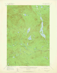
 1951 Chain Lakes1951 Print · USGSFranklin County's remote northern borderlands are shown here in the early fifties, following the historic Arnold Trail through the Chain of Ponds Lakes. Researchers can locate seasonal outposts like Caribou Camp or Lowelltown and trace the waterways of JIM POND and SEVEN PONDS.
 - 1956 Map of Dixfield, 1958 Print
 1956 Dixfield1958 Print · USGSIn the mid-1950s, the western Maine landscape centered on the bustling river town of Dixfield and the expanses of Mt Blue State Park. Genealogists and historians can trace family cemeteries like Birchland Cem and old industrial sites like Hildreths Mill.5 unique versions available
 - 1956 Map of Norridgewock, 1958 Print
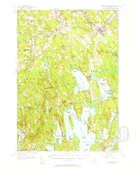 1956 Norridgewock1958 Print · USGSSomerset and Kennebec counties are shown here in the mid-1950s, centered on the river convergence at Norridgewock. Genealogists and historians can trace local school districts like Whittier Sch and explore lakefront landmarks including Camp Abena and The Serpentine.3 unique versions available
 - 1956 Map of Farmington, 1959 Print
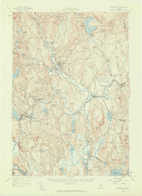 1956 Farmington1959 Print · USGSMid-century Franklin County, Maine, reveals a landscape of river-driven industry and upland farming. Researchers can trace the rail connections through Wilton Station or locate family roots near Knowltons Corner, Intervale School, and Savage Cemetery.3 unique versions available
 - 1956 Map of Little Bigelow Mtn, 1959 Print
 1956 Little Bigelow Mtn1959 Print · USGSSomerset and Franklin counties are shown here in the mid-fifties, just after the waters of the Dead River were impounded. Researchers can locate remote seasonal outposts like West Carry Camps, the Highland Sch, and the winding path of the Appalachian Trail.4 unique versions available
 - 1956 Map of Stratton, 1959 Print
 1956 Stratton1959 Print · USGSThe Franklin County highlands in the mid-1950s show a landscape defined by the expansion of Flagstaff Lake and the timber economy. Researchers can trace the Appalachian Trail over Bigelow Mountain or locate the Flagstaff Memorial Church and the Coplin School.3 unique versions available
 - 1956 Map of Bangor, 1966 Print
 1956 Bangor1966 Print · USGSMid-century Maine comes alive in this survey of the rugged coast and river valleys during the 1950s. Genealogists and historians can trace the vital rail corridors of the Maine Central RR connecting timber towns like Old Town to the coast at Bar Harbor.3 unique versions available
 - 1956 Map of Lewiston, 1975 Print
 1956 Lewiston1975 Print · USGSThe Northern New England interior is documented here in the mid-fifties, from the industrial Androscoggin River to the high peaks of the White Mountains. Trace the Grand Trunk Railway through mountain passes or locate family landmarks near Sabbathday Lake and Bretton Woods.
 - 1958 Map of Spencer Lake, 1960 Print
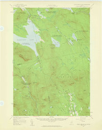
 1958 Spencer Lake1960 Print · USGSSomerset County’s remote wilderness is documented here in the late fifties, showing a landscape shaped by the timber and sporting industries. Researchers can locate specific seasonal outposts like Hobbstown Depot Camp, Kibby Kamp, and the Spencer Dam.3 unique versions available
End of results
Showing maps 1-12 of 12
Top cities of Franklin County
- Farmington historical maps
- Jay historical maps
- Wilton historical maps
- New Sharon historical maps
- Chesterville historical maps
- Rangeley historical maps
See more
Frequently asked questions
- What are the different types of historical maps available for Franklin County?
- What is the oldest map of Franklin County?
- Where can I purchase historical maps of Franklin County for my home or office?
- Where can I download high-res historical maps of Franklin County?
- Are there historical topographic maps available for Franklin County?
- Is there historical aerial imagery available for Franklin County?
- Where are historical maps of Franklin County sourced from?