1980s Maps of Franklin County, Maine
Explore 31 historic maps of Franklin County from the 1980s. These maps offer a rare glimpse into what life looked like during the 1980s — showing old roads, neighborhoods, homes, and landmarks that have changed or disappeared over time.
Whether you're researching your family's past, planning a metal detecting trip, or studying how Franklin County's landscape evolved across the 1980s, these high-resolution maps are a powerful tool for exploring the history of this region.
- Focus on a specific era: All maps on this page are from the 1980s, giving you a focused view of this time period.
- See what’s changed: Compare century-old streets, trails, and buildings to today's modern landscape using overlays and satellite layers.
- Research with precision: Use these maps for genealogy, historical research, land use analysis, or educational projects.
- View, download, or print: Maps are fully viewable online in high resolution, and can be downloaded or printed for your own records.
Start exploring Franklin County's history through authentic maps from the 1980s. This is your window into the past.
Franklin County, ME maps
(31)- 1982 Map of Belgrade Lakes, 1983 Print
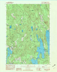 1982 Belgrade Lakes1983 Print · USGSBelgrade Lakes and its surrounding chain of ponds are captured here in the early 1980s, showcasing a landscape defined by seasonal residency and rugged hills. Researchers can trace local landmarks like Mount Vernon Airport, the Vienna Ch, and the shoreline of Great Belgrade Pond.3 unique versions available
 - 1982 Map of Mercer, 1983 Print
 1982 Mercer1983 Print · USGSSomerset County's rural river valleys are shown in detail during the late twentieth century as traditional crossroads communities remained the focus of local life. Researchers can locate family burial sites like Hampshire Hill Cem or trace the early footprint of Beech Hill Airport and Starks Ch.
 - 1984 Map of Rangeley, 1985 Print
 1984 Rangeley1985 Print · USGSThe Rangeley Lakes region in the early eighties is captured here as a premier outdoor destination centered on the expansive Rangeley Lake. Researchers can locate lakeside landmarks like Mingo Springs, the local Cem, and the Rangeley Municipal Airport.
 - 1984 Map of Madrid, 1985 Print
 1984 Madrid1985 Print · USGSThe Sandy River highlands in the early 1980s reveal a landscape of mountain peaks and isolated valley settlements. Genealogists and local historians can trace the remote roads and family-named landmarks like Rowe Hill, Toothaker Pond, and the village of Madrid.
 - 1984 Map of Metallak Mtn, 1985 Print
 1984 Metallak Mtn1985 Print · USGSOxford County's high wilderness is captured here in the mid-1980s, showcasing the intersection of timber lands and glacial lakes. Hikers and historians can trace the Appalachian Trail across Elephant Mountain or locate the shoreline settlements of South Arm and Mosquito.2 unique versions available
 - 1984 Map of Houghton, 1985 Print
 1984 Houghton1985 Print · USGSThe high peaks and timberlands of Franklin and Oxford counties are captured here in the early eighties. Genealogists and hikers can trace the Old Railroad Grade through the mountains, locate the remote Bemis settlement, or find Angel Falls.
 - 1984 Map of Jackson Mountain, 1985 Print
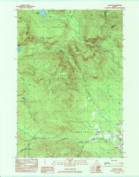
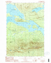
 1984 Jackson Mountain1985 Print · USGSFranklin County's high country is captured here in the mid-1980s, where the Appalachian Trail traverses a landscape of remote peaks and ponds. Trace the local topography from Smalls Falls to the high waters of Jackson Pond and Tumbledown Pond.
 - 1984 Map of Redington, 1985 Print
 1984 Redington1985 Print · USGSFranklin County's high ridges and timber valleys are captured in the early 1980s, showcasing the intersection of wilderness recreation and industrial history. Researchers can trace the Old RR Grade along Orbeton Stream and locate small settlements like Perham Junction or East Madrid.2 unique versions available
 - 1984 Map of Phillips, 1985 Print
 1984 Phillips1985 Print · USGSFranklin County's river valleys and timberlands are captured here in the early 1980s as the local economy transitioned from its industrial rail roots. Genealogists and hikers can trace the Old Railroad Grade along the Sandy River or locate family sites near Avon Corner and Sampson Hill.
 - 1984 Map of Mount Abraham, 1985 Print
 1984 Mount Abraham1985 Print · USGSFranklin County's high ridges and river valleys are captured in the mid-eighties as timber and recreation shaped the local economy. Researchers can trace the Old RR Grade near Salem or follow the Appalachian National Scenic Trail over Spalding Mtn.2 unique versions available
 - 1984 Map of Oquossoc, 1985 Print
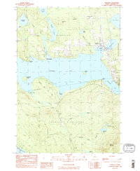
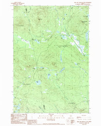
 1984 Oquossoc1985 Print · USGSMaine's western lakes region comes into focus during the mid-1980s, centered on the historic sporting and rail hub of Oquossoc. Genealogists and local historians can trace the shorelines of Cupsuptic Lake to find named camps and landmarks like Upper Dam and Pleasant Island.2 unique versions available
 - 1984 Map of Andover, 1985 Print
 1984 Andover1985 Print · USGSOxford County mountain terrain and the upper reaches of the Ellis River are documented here in the early 1980s. Hikers and local historians can trace the Appalachian Trail past The Cataracts or locate remote landmarks like C Pond and the Hall Mtn Lean-to.2 unique versions available
 - 1985 Map of Saddleback Mountain
 1985 Saddleback Mountain1985 Print · USGSThe Maine mountains in the mid-1980s were a landscape of high peaks and historic transit corridors. You can trace the Old RR Grade and the Appalachian Trail through Dallas Plantation past Saddleback Lake.2 unique versions available
 - 1985 Map of Skowhegan, 1986 Print
 1985 Skowhegan1986 Print · USGSCentral Maine in the mid-eighties shows a landscape of river-driven industry and rural crossroads. Genealogists can trace family names and farmsteads near Lake George or along the Maine Central Railroad through Pittsfield and Burnham.2 unique versions available
 - 1986 Map of Flagstaff Lake
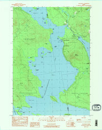
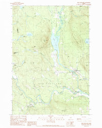
 1986 Flagstaff Lake1986 Print · USGSThe Maine North Woods and the Dead River valley are captured here in the mid-1980s, an era of established hydroelectric lakes and outdoor recreation. Genealogists and researchers can trace the vicinity of Kennebago Settlement, Langtown Mill, and the villages of Stratton and Eustis.
 - 1986 Map of Megantic
 1986 Megantic1986 Print · USGSSettlement and industry along the international border define this mid-1980s survey of the Maine north woods. Genealogists and historians can trace the Canadian Pacific rail line through Jackman Station, Lowelltown, and the Jackman Mill.
 - 1986 Map of Lewiston
 1986 Lewiston1986 Print · USGSMaine’s industrial river valleys and western mountain foothills are captured here in the mid-eighties as rail and road networks tied the region together. Genealogists and historians can trace the development of mill towns and lakefront settlements from Lisbon to Bethel, following the Androscoggin River and the path of the Maine Central Railroad.2 unique versions available
 - 1986 Map of Rumford
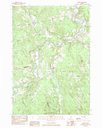
 1986 Rumford1986 Print · USGSWestern Maine in the mid-eighties shows a rugged landscape of industrial river towns and high-country timber plantations. Trace the rail-and-river economy through Rumford, Dixfield, and the Maine Central RR or locate the historic campus of Farmington State College.
 - 1989 Map of Kind and Bartlett Mtn.
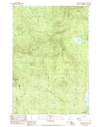
 1989 Kind and Bartlett Mtn.1989 Print · USGSSomerset and Franklin counties meet in this 1980s Maine wilderness, where timberlands and high-country waters define the terrain. Trace remote backcountry sites like Kibby Kamp or follow the shoreline of King and Bartlett Lake and Joe Pokum Pond.2 unique versions available
 - 1989 Map of Stratton
 1989 Stratton1989 Print · USGSThe northern Maine woods meet the expansive waters of Flagstaff Lake in the late 1980s, documenting a landscape shaped by the Dead River. Researchers can locate family sites near the village of Stratton, the small Cem near the river, and the high summits of Bigelow Mountain.
 - 1989 Map of New Vineyard
 1989 New Vineyard1989 Print · USGSFranklin County's high ridges and river valleys are captured here in the late eighties, showing the settlement of New Vineyard and West Mills. Genealogists and hikers can trace old routes past Mill Pond, local Cem sites, and the peaks of the New Vineyard Mountains.
 - 1989 Map of Tumbledown Mtn
 1989 Tumbledown Mtn1989 Print · USGSSomerset County’s remote timberlands are captured here in the late eighties, showing a landscape defined by industrial logging and high-country peaks. Trace the network of forest roads leading to Tumbledown Mtn, Blakeslee Lake, and the West Branch Spencer Stream.
 - 1989 Map of New Portland
 1989 New Portland1989 Print · USGSThe river valleys of Somerset County appear here in the late eighties as a network of small settlements and rugged timberland. Researchers can trace family sites near New Portland, find various Cem locations, or follow the path of the Carrabassett River.
 - 1989 Map of Poplar Mountain
 1989 Poplar Mountain1989 Print · USGSFranklin County's high country is captured here in the late eighties, centered on the corridor of the Carrabassett River. Researchers can trace the layout of mountain settlements like Carrabassett and Records or locate isolated waters like Redington Pond and Tufts Pond.
 - 1989 Map of The Horns
 1989 The Horns1989 Print · USGSHigh peaks and flooded valleys define the Somerset County landscape in the late eighties. Hikers and historians can trace the Appalachian National Scenic Trail over The Horns and locate sites like the Bigelow Lookout Tower and Hurricane Island.
Showing maps 1-25 of 31
Top cities of Franklin County
- Farmington historical maps
- Jay historical maps
- Wilton historical maps
- New Sharon historical maps
- Chesterville historical maps
- Rangeley historical maps
See more
Frequently asked questions
- What are the different types of historical maps available for Franklin County?
- What is the oldest map of Franklin County?
- Where can I purchase historical maps of Franklin County for my home or office?
- Where can I download high-res historical maps of Franklin County?
- Are there historical topographic maps available for Franklin County?
- Is there historical aerial imagery available for Franklin County?
- Where are historical maps of Franklin County sourced from?