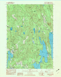
1982 Map of Belgrade Lakes
USGS Topo · Published 1983About this map
Belgrade Lakes sits at the narrow passage between the expansive waters of Long Pond and Great Belgrade Pond, serving as a central point in this early 1980s topographical survey. The landscape is defined by its complex network of interconnected water bodies, including Flying Pond and Watson Pond, which are separated by prominent ridgelines such as Vienna Mountain and McGaffey Mountain. The settlement of Vienna is documented with its local Vienna Ch, while Rome Corner and Mount Vernon anchor the surrounding townships.
Find a feature on this map
60 named features on this map. Tap any name to fly to it.
Don’t see what you’re looking for? This feature index may not catch every label — zoom into the map to look around manually.
Map Details
Editions of this 1982 Belgrade Lakes Map
3 editions found
Other maps of this area

1892 · Augusta
USGS Topo · 1:62,500

1894 · Norridgewock
USGS Topo · 1:62,500

1898 · Norridgewock
USGS Topo · 1:62,500

1910 · Livermore
USGS Topo · 1:62,500

1912 · Livermore
USGS Topo · 1:62,500

1924 · Farmington
USGS Topo · 1:62,500

1941 · Livermore
USGS Topo · 1:62,500

1941 · Augusta
USGS Topo · 1:62,500

1943 · Augusta
USGS Topo · 1:62,500

1943 · Norridgewock
USGS Topo · 1:62,500