1940s Maps of Rangeley, Maine
Explore 4 historic maps of Rangeley from the 1940s. These maps offer a rare glimpse into what life looked like during the 1940s — showing old roads, neighborhoods, homes, and landmarks that have changed or disappeared over time.
Whether you're researching your family's past, planning a metal detecting trip, or studying how Rangeley's landscape evolved across the 1940s, these high-resolution maps are a powerful tool for exploring the history of this region.
- Focus on a specific era: All maps on this page are from the 1940s, giving you a focused view of this time period.
- See what’s changed: Compare century-old streets, trails, and buildings to today's modern landscape using overlays and satellite layers.
- Research with precision: Use these maps for genealogy, historical research, land use analysis, or educational projects.
- View, download, or print: Maps are fully viewable online in high resolution, and can be downloaded or printed for your own records.
Start exploring Rangeley's history through authentic maps from the 1940s. This is your window into the past.
Rangeley, ME maps
(4)- 1940 Map of Oquossoc, 1955 Print
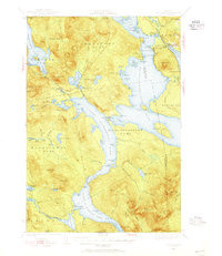 1940 Oquossoc1955 Print · USGSOxford County at the dawn of the 1940s remained a landscape of timber and water, centered on the historic settlements of the Rangeley Lakes. Genealogists and researchers can trace early lakefront communities and the vital water-control sites at Upper Dam, Aziscohos Dam, and Oquossoc.4 unique versions available
 - 1942 Map of Oquossoc
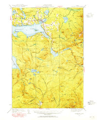
 1942 Oquossoc1942 Print · USGSMaine's western lakes and timberlands are captured here in the early 1940s, showing a landscape defined by water and woods. You can trace the Appalachian Trail through the high country or locate remote sporting sites like the Oquossoc Angling Assn and Middle Dam.3 unique versions available
 - 1949 Map of Jackman
 1949 Jackman1949 Print · USGSThe Quebec and Maine borderlands are shown in great detail during the late 1940s, highlighting the industrial and natural geography of the region. Trace old rail lines like the Canadian Pacific and locate settlements from Sherbrooke to Scotstown.2 unique versions available
 - 1949 Map of Rangeley, 1955 Print
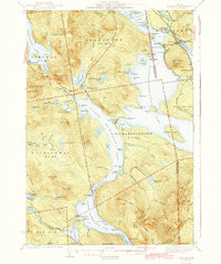
 1949 Rangeley1955 Print · USGSThe western Maine highlands come into focus in the late 1940s, showcasing the region's transition into a premier recreation destination. Track the Appalachian Trail as it crosses peaks like Saddleback Mtn and Bemis Mtn, or locate the Airport and landmarks around Rangeley Lake.4 unique versions available
End of results
Showing maps 1-4 of 4
Top cities near Rangeley
- Eustis historical maps
- Weld historical maps
- Dallas Plantation historical maps
- Rangeley Plantation historical maps
- Madrid Township historical maps
- Coplin Plantation historical maps
See more
Top neighborhoods of Rangeley
- Bald Mountain historical maps
- Mountainview historical maps
- Oquossoc historical maps
- Mingo Springs historical maps
- Macy historical maps
Frequently asked questions
- What are the different types of historical maps available for Rangeley?
- What is the oldest map of Rangeley?
- Where can I purchase historical maps of Rangeley for my home or office?
- Where can I download high-res historical maps of Rangeley?
- Are there historical topographic maps available for Rangeley?
- Is there historical aerial imagery available for Rangeley?
- Where are historical maps of Rangeley sourced from?