1970s Maps of Rangeley, Maine
Explore 6 historic maps of Rangeley from the 1970s. These maps offer a rare glimpse into what life looked like during the 1970s — showing old roads, neighborhoods, homes, and landmarks that have changed or disappeared over time.
Whether you're researching your family's past, planning a metal detecting trip, or studying how Rangeley's landscape evolved across the 1970s, these high-resolution maps are a powerful tool for exploring the history of this region.
- Focus on a specific era: All maps on this page are from the 1970s, giving you a focused view of this time period.
- See what’s changed: Compare century-old streets, trails, and buildings to today's modern landscape using overlays and satellite layers.
- Research with precision: Use these maps for genealogy, historical research, land use analysis, or educational projects.
- View, download, or print: Maps are fully viewable online in high resolution, and can be downloaded or printed for your own records.
Start exploring Rangeley's history through authentic maps from the 1970s. This is your window into the past.
Rangeley, ME maps
(6)- 1970 Map of Kennebago Lake, 1973 Print
 1970 Kennebago Lake1973 Print · USGSNorthwestern Maine at the start of the 1970s remained a landscape of sporting camps and timber townships. Genealogists and researchers can trace the remote outposts of Grants Camps and Kennebago Lake Camps among the peaks of East Kennebago Mtn.
 - 1976 Map of Sherbrooke
 1976 Sherbrooke1976 Print · USGSThe northern Maine woods and Quebec’s Eastern Townships meet in this mid-century survey of the rugged international borderlands. Genealogists and historians can trace rail-and-river connections through Thetford Mines, follow the Dead River to Flagstaff Lake, or locate small border crossings at Stanhope and Beecher Falls.2 unique versions available
 - 1977 Map of Kennebago Lake, 1983 Print
 1977 Kennebago Lake1983 Print · USGSThe Maine wilderness of the late seventies is captured in this orthophoto, showing the unpopulated mountain landscapes near Loon Lake. Researchers can trace the drainages of Big Sag Brook and the high ridges of Spotted Mountain.
 - 1977 Map of Kennebago, 1983 Print
 1977 Kennebago1983 Print · USGSOxford County's timberlands and river systems are shown with photographic precision in the late seventies. Researchers can trace the winding Kennebago River and the shoreline of Cupsuptic Lake as they appeared during this era of forest management.
 - 1977 Map of Oquossoc, 1983 Print
 1977 Oquossoc1983 Print · USGSOxford County's lake country is captured in the late 1970s, showcasing the intricate shoreline of the Rangeley Lakes region. Trace the footprints of Oquossoc and South Rangeley or locate the infrastructure at Upper Dam and Bald Mountain.
 - 1977 Map of Rangeley, 1983 Print
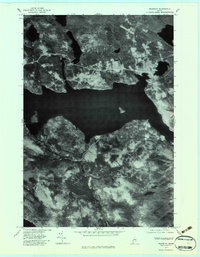 1977 Rangeley1983 Print · USGSRangeley and its famous lakes are captured in high-resolution aerial detail during the late seventies. Researchers can trace the shoreline developments of Rangeley Lake or locate specific buildings and clearings in Mingo Springs and Rangeley.
End of results
Showing maps 1-6 of 6
Top cities near Rangeley
- Eustis historical maps
- Weld historical maps
- Dallas Plantation historical maps
- Rangeley Plantation historical maps
- Madrid Township historical maps
- Coplin Plantation historical maps
See more
Top neighborhoods of Rangeley
- Bald Mountain historical maps
- Mountainview historical maps
- Oquossoc historical maps
- Mingo Springs historical maps
- Macy historical maps
Frequently asked questions
- What are the different types of historical maps available for Rangeley?
- What is the oldest map of Rangeley?
- Where can I purchase historical maps of Rangeley for my home or office?
- Where can I download high-res historical maps of Rangeley?
- Are there historical topographic maps available for Rangeley?
- Is there historical aerial imagery available for Rangeley?
- Where are historical maps of Rangeley sourced from?