1940s Maps of Hancock County, Maine
Explore 29 historic maps of Hancock County from the 1940s. These maps offer a rare glimpse into what life looked like during the 1940s — showing old roads, neighborhoods, homes, and landmarks that have changed or disappeared over time.
Whether you're researching your family's past, planning a metal detecting trip, or studying how Hancock County's landscape evolved across the 1940s, these high-resolution maps are a powerful tool for exploring the history of this region.
- Focus on a specific era: All maps on this page are from the 1940s, giving you a focused view of this time period.
- See what’s changed: Compare century-old streets, trails, and buildings to today's modern landscape using overlays and satellite layers.
- Research with precision: Use these maps for genealogy, historical research, land use analysis, or educational projects.
- View, download, or print: Maps are fully viewable online in high resolution, and can be downloaded or printed for your own records.
Start exploring Hancock County's history through authentic maps from the 1940s. This is your window into the past.
Hancock County, ME maps
(29)- 1940 Map of Ellsworth, 1957 Print
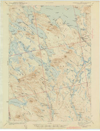
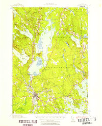 1940 Ellsworth1957 Print · USGSHancock County at the start of the 1940s reveals a landscape of tidal bays and timbered ridges surrounding the hub of Ellsworth. Genealogists and local historians can trace rail lines at Washington Junction, find rural schoolhouses like Beechland Sch, and locate the old Franklin Road North Hancock Post Office.
 - 1941 Map of Tug Mountain, 1958 Print
 1941 Tug Mountain1958 Print · USGSWashington County during the early 1940s was a landscape of timber and remote sporting camps. You can trace early backcountry retreats like Worcester Lodge and Hartford Camp or follow the route of the historic Air Line Road past Tug Mountain.2 unique versions available
 - 1941 Map of Castine, 1959 Print
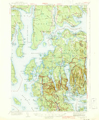
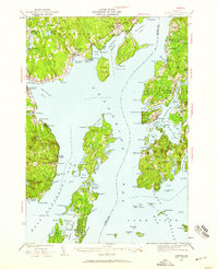 1941 Castine1959 Print · USGSPenobscot Bay and its storied coastal villages appear here in the early 1940s, showing the intersection of maritime trade and rural Maine life. Genealogists and historians can trace the rail terminals at Mack Pt, local schools like Park Sch, and the historical site of Fort George.4 unique versions available
 - 1941 Map of Wabassus Lake, 1962 Print
 1941 Wabassus Lake1962 Print · USGSThe Downeast timberlands of Washington County were a labyrinth of logging camps and glacial lakes just before the mid-century. Researchers can trace the water-and-woods economy through Farm Cove Dam, the Dennison Portage, and the village of Grand Lake Stream.
 - 1941 Map of Vinalhaven, 1962 Print
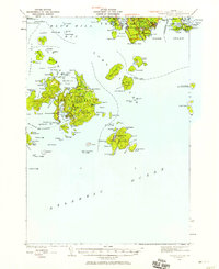
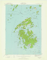 1941 Vinalhaven1962 Print · USGSPenobscot Bay is captured in high detail during the early 1940s, showing the intricate island communities of the Fox Islands. Researchers can trace family sites near Seaview Cem, locate maritime landmarks like Heron Neck L H, and explore the geography of Hurricane Island.3 unique versions available
 - 1942 Map of Bar Harbor
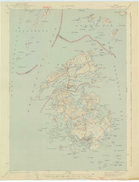
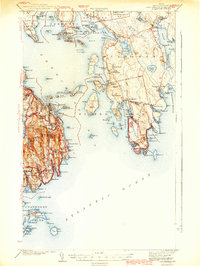 1942 Bar Harbor1942 Print · USGSMount Desert Island and the Schoodic Peninsula are shown just before the war in this detailed coastal survey. Genealogists and historians can trace the foundations of Bar Harbor, locate the village of Islesford, and explore landmarks like Chicken Mill Pond.4 unique versions available
 - 1942 Map of Orland
 1942 Orland1942 Print · USGSIn the early 1940s, the rugged interior between the Penobscot River and Ellsworth was a landscape of high summits and conservation-focused industry. Genealogists and historians can trace old homesteads and landmarks like Bucks Mills, the U S Fish Hatchery, and the scattered settlements of East Orland and North Ellsworth.
 - 1942 Map of Cherryfield
 1942 Cherryfield1942 Print · USGSCoastal Washington County in the early 1940s reveals a landscape of tidal bays and glacial barrens. Trace family roots and old land patterns in Cherryfield, Millbridge, and Harrington, or locate the scientific U S C & G SURVEY BASE LINE.
 - 1942 Map of Ellsworth
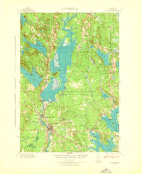 1942 Ellsworth1942 Print · USGSHancock County enters the early years of the war with its rail and river networks fully matured. Genealogists and historians can trace the foundations of local life through rural landmarks like the No 8 Plantation Sch, the rail hub at Washington Junction, and the post office at North Hancock P O.
 - 1942 Map of Mount Desert
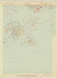
 1942 Mount Desert1942 Print · USGSMount Desert Island and the surrounding Maine coast appear here just as the war began, showing the interplay of maritime life and early conservation. Genealogists can locate family landmarks like South Surry Cem and long-standing schools such as Bayside Sch or The Narrows Sch.5 unique versions available
 - 1942 Map of Tunk Lake
 1942 Tunk Lake1942 Print · USGSHancock County’s inland peaks and coastal villages are captured here during the early 1940s, just as aerial photography began to modernize regional mapping. Researchers can locate the Tunk Lake Sch, coastal rail stops at Waukeag, and the prominent Fire Tower on Schoodic Mtn.
 - 1942 Map of Bucksport
 1942 Bucksport1942 Print · USGSThe mid-century Penobscot River valley is captured here just as the river-and-rail economy defined local life. Genealogists and historians can trace family-named crossroads like Nealeys Corner and Ellingwoods Corner or locate the landmark Fort Knox and Prospect Ferry.
 - 1942 Map of Deer Isle, 1958 Print
 1942 Deer Isle1958 Print · USGSCoastal Maine life in the 1940s centers on the granite industry and maritime trade routes throughout Deer Isle and the Penobscot Bay islands. Genealogists and historians can trace the foundations of local economies through the QUARRIES at Stonington and the many family-named landmarks like Greenlaw Neck or Conary Head.3 unique versions available
 - 1943 Map of Tug Mountain
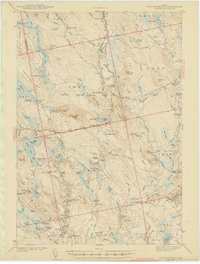 1943 Tug Mountain1943 Print · USGSThe Maine woods in the early 1940s reveal a network of logging dams and remote seasonal camps. Genealogists and historians can trace family-named sites like Worcester Lodge, Hartford Camp, and Ben Tucker Mtn along the Machias River.2 unique versions available
 - 1943 Map of Wabassus Lake
 1943 Wabassus Lake1943 Print · USGSThe Maine wilderness of Washington County comes alive in the 1940s through its intricate network of lakes, logging camps, and traditional portages. Local historians can trace the foundations of Grand Lake Stream or locate remote sites like The Birches and Holland Camp.3 unique versions available
 - 1943 Map of Castine
 1943 Castine1943 Print · USGSMid-century Penobscot Bay life is charted here during the early 1940s, from the historic streets of the mainland to the isolated island harbors. Genealogists can trace family connections at Bethany Chapel or locate the old Farnham Sch and the rail depot at Searsport Sta.3 unique versions available
 - 1943 Map of Swans Island, 1958 Print
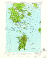
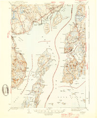
 1943 Swans Island1958 Print · USGSCoastal Hancock County at the height of the Second World War reveals a landscape of isolated island communities and maritime commerce. Genealogists and historians can trace family roots through the settlements of Atlantic, Minturn, and Frenchboro, or locate landmarks like the Blue Hill Bay LH and Little Duck I Bird Sanctuary.3 unique versions available
 - 1944 Map of Blue Hill
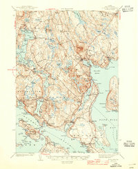 1944 Blue Hill1944 Print · USGSHancock County’s rugged coastline and seafaring villages are captured here in the mid-1940s, just as modern infrastructure began to bridge these isolated peninsulas. Genealogists can trace family roots through sites like Hilltop Cem, the Grays Corner Sch, and the Deer Isle-Sedgwick Bridge.3 unique versions available
 - 1944 Map of Vinalhaven
 1944 Vinalhaven1944 Print · USGSThe Fox Islands of Maine are captured here during the 1940s, showing the intricate island-and-bay network of Penobscot Bay. Genealogists can trace early family sites like Fuller Cem and Browns Cem or locate maritime landmarks such as Browns Head LH.2 unique versions available
 - 1944 Map of Deer Isle
 1944 Deer Isle1944 Print · USGSPenobscot Bay and the Eggemoggin Reach appear here in the early 1940s, highlighting the granite and maritime hubs of the Maine coast. Genealogists and historians can locate family homes near Stonington, coastal Quarries, and landmarks like Forest Cem.2 unique versions available
 - 1944 Map of Orono, 1954 Print
 1944 Orono1954 Print · USGSThe Penobscot River corridor is captured here in the mid-1940s, showing the early footprint of the University of Maine and the industrial activity of Old Town. Genealogists and historians can trace family locations through French Settlement, Woodlawn Cem, and the Old Gold Mine.2 unique versions available
 - 1945 Map of Swans Island
 1945 Swans Island1945 Print · USGSCoastal Maine's island communities thrive amidst the granite shores and deep harbors of Hancock County during the mid-1940s. Trace the isolated settlements of Atlantic, Minturn, and Frenchboro, or locate family sites like the Stockbridge Cem and the Blue Hill Bay LH.2 unique versions available
 - 1946 Map of Orono
 1946 Orono1946 Print · USGSPenobscot County industry and academia meet along the river in the mid-forties. Genealogists and historians can trace the development of Marsh Island, locate the University of Maine campus, and find local landmarks like the Old Gold Mine Trail.2 unique versions available
 - 1948 Map of Bangor
 1948 Bangor1948 Print · USGSThe Maine coast and its industrial river valleys are captured here shortly after the war, showing the vital shipping and rail hubs of the late 1940s. Genealogists and historians can trace the tracks of the Maine Central RR connecting Bangor, Augusta, and Old Town.
 - 1948 Map of Bath
 1948 Bath1948 Print · USGSMid-coast Maine’s intricate shoreline and island outposts are captured here just after the war. Researchers can trace historic maritime settlements from Bath to Friendship and locate remote landmarks like Monhegan Island and Pemaquid Point.2 unique versions available
Showing maps 1-25 of 29
Top cities of Hancock County
- Ellsworth historical maps
- Bar Harbor historical maps
- Bucksport historical maps
- Blue Hill historical maps
- Hancock historical maps
- Orland historical maps
See more
Frequently asked questions
- What are the different types of historical maps available for Hancock County?
- What is the oldest map of Hancock County?
- Where can I purchase historical maps of Hancock County for my home or office?
- Where can I download high-res historical maps of Hancock County?
- Are there historical topographic maps available for Hancock County?
- Is there historical aerial imagery available for Hancock County?
- Where are historical maps of Hancock County sourced from?