1970s Maps of Hancock County, Maine
Explore 13 historic maps of Hancock County from the 1970s. These maps offer a rare glimpse into what life looked like during the 1970s — showing old roads, neighborhoods, homes, and landmarks that have changed or disappeared over time.
Whether you're researching your family's past, planning a metal detecting trip, or studying how Hancock County's landscape evolved across the 1970s, these high-resolution maps are a powerful tool for exploring the history of this region.
- Focus on a specific era: All maps on this page are from the 1970s, giving you a focused view of this time period.
- See what’s changed: Compare century-old streets, trails, and buildings to today's modern landscape using overlays and satellite layers.
- Research with precision: Use these maps for genealogy, historical research, land use analysis, or educational projects.
- View, download, or print: Maps are fully viewable online in high resolution, and can be downloaded or printed for your own records.
Start exploring Hancock County's history through authentic maps from the 1970s. This is your window into the past.
Hancock County, ME maps
(13)- 1973 Map of Cape Rosier, 1976 Print
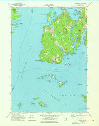 1973 Cape Rosier1976 Print · USGSCoastal Hancock County in the early seventies shows a landscape of granite heights and tidal reaches. Genealogists and historians can trace family-named sites like John B Mtn or find old burial grounds at Evergreen Cem and Bayview Cem.3 unique versions available
 - 1973 Map of Islesboro, 1976 Print
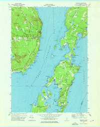 1973 Islesboro1976 Print · USGSThe islands of Penobscot Bay appear in the 1970s, showcasing the maritime connections of Islesboro and Dark Harbor. Trace local genealogy and landmarks across Seven Hundred Acre Island, the Saturday Cove Cem, and the Islesboro Ferry Toll.2 unique versions available
 - 1973 Map of Castine, 1977 Print
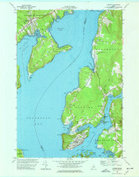 1973 Castine1977 Print · USGSThe Maine coast near the confluence of the Penobscot and Bagaduce Rivers is captured here in the early 1970s. Local historians can trace the foundations of Ft George, the route of the British Canal, and the grounds of the Maritime Academy in Castine.3 unique versions available
 - 1975 Map of Nicatous Lake SE, 1980 Print
 1975 Nicatous Lake SE1980 Print · USGSThe timberlands and glacial waters of Hancock County come into focus in the mid-1970s. Trace the logging roads through the forest and locate landmarks like Sabao Mountain in this detailed aerial orthophoto.
 - 1975 Map of Nicatous Lake SW, 1980 Print
 1975 Nicatous Lake SW1980 Print · USGSThe Maine wilderness near Quagus is documented in this 1970s aerial survey, showing the deep woods and interior waterways in a literal photographic view. Researchers can examine the specific timber patterns and natural shoreline of Quagus as they existed decades ago.
 - 1975 Map of Saponac SW, 1980 Print
 1975 Saponac SW1980 Print · USGSThe rural Maine woods around Greenfield are captured in high detail during the mid-seventies. Local historians and land-use researchers can trace the specific boundaries of clearings, forest tracks, and early structures within the Greenfield settlement area.
 - 1975 Map of Nicatous Lake NW, 1980 Print
 1975 Nicatous Lake NW1980 Print · USGSHancock County’s deep woods and waters are captured in the mid-1970s through this detailed aerial survey. Researchers can trace the winding Passadumkeag River and study the intricate shoreline of Nicatous Lake and the nearby Heath.
 - 1975 Map of Saponac NE, 1980 Print
 1975 Saponac NE1980 Print · USGSThe dense forests of Penobscot County are seen here in the mid-1970s, revealing the untouched character of the Maine woods. Researchers can trace the winding path of the Passadumkeag River through this isolated timberland.
 - 1975 Map of Springfield SE, 1980 Print
 1975 Springfield SE1980 Print · USGSJunior Lake and the surrounding Maine timberlands are captured in photographic detail during the mid-seventies. Researchers can examine the unaltered shorelines of Junior Lake and the rural layout of Springfield in this unique aerial perspective.
 - 1975 Map of Nicatous Lake NE, 1980 Print
 1975 Nicatous Lake NE1980 Print · USGSThe interior of Hancock County is captured in this mid-seventies aerial survey, showing the deep woods of eastern Maine. Researchers can examine the shoreline and surrounding timber around Duck Lake to see the landscape as it stood before modern development.
 - 1975 Map of Saponac SE, 1980 Print
 1975 Saponac SE1980 Print · USGSCovers Hancock County, including Great Pond, T39 MD BPP, and other nearby areas
 - 1975 Map of Wabassus Lake SW, 1980 Print
 1975 Wabassus Lake SW1980 Print · USGSWashington County's timberlands are seen in detail during the mid-seventies through this aerial orthophotoquad. Researchers can trace the untouched terrain surrounding Fletcher Peak, Bald Mountain, and the quiet slopes of Knox Mountain.
 - 1976 Map of Eastport
 1976 Eastport1976 Print · USGSThe maritime borderlands of Maine and Nova Scotia come alive in this mid-seventies survey of the Downeast coast. Genealogists and historians can trace the shoreline settlements of Eastport, Lubec, and Machias, or cross the channel to find Acadian villages like Church Point and Meteghan Centre.
End of results
Showing maps 1-13 of 13
Top cities of Hancock County
- Ellsworth historical maps
- Bar Harbor historical maps
- Bucksport historical maps
- Blue Hill historical maps
- Hancock historical maps
- Orland historical maps
See more
Frequently asked questions
- What are the different types of historical maps available for Hancock County?
- What is the oldest map of Hancock County?
- Where can I purchase historical maps of Hancock County for my home or office?
- Where can I download high-res historical maps of Hancock County?
- Are there historical topographic maps available for Hancock County?
- Is there historical aerial imagery available for Hancock County?
- Where are historical maps of Hancock County sourced from?