1980s Maps of Mount Vernon, Maine
Explore 6 historic maps of Mount Vernon from the 1980s. These maps offer a rare glimpse into what life looked like during the 1980s — showing old roads, neighborhoods, homes, and landmarks that have changed or disappeared over time.
Whether you're researching your family's past, planning a metal detecting trip, or studying how Mount Vernon's landscape evolved across the 1980s, these high-resolution maps are a powerful tool for exploring the history of this region.
- Focus on a specific era: All maps on this page are from the 1980s, giving you a focused view of this time period.
- See what’s changed: Compare century-old streets, trails, and buildings to today's modern landscape using overlays and satellite layers.
- Research with precision: Use these maps for genealogy, historical research, land use analysis, or educational projects.
- View, download, or print: Maps are fully viewable online in high resolution, and can be downloaded or printed for your own records.
Start exploring Mount Vernon's history through authentic maps from the 1980s. This is your window into the past.
Mount Vernon, ME maps
(6)- 1980 Map of Readfield
 1980 Readfield1980 Print · USGSThe Maine lakeside communities of Kennebec County are captured here during the 1970s, showing a landscape of family-named roads and rural settlements. Genealogists can trace property history through Robinson Cem and Potash Cem, or locate the old Readfield Depot along the Maine Central line.
 - 1982 Map of Belgrade Lakes, 1983 Print
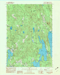 1982 Belgrade Lakes1983 Print · USGSBelgrade Lakes and its surrounding chain of ponds are captured here in the early 1980s, showcasing a landscape defined by seasonal residency and rugged hills. Researchers can trace local landmarks like Mount Vernon Airport, the Vienna Ch, and the shoreline of Great Belgrade Pond.3 unique versions available
 - 1984 Map of Augusta
 1984 Augusta1984 Print · USGSMid-coast and central Maine were undergoing steady change in the mid-eighties as traditional river and coastal industries met expanding recreation. You can trace the Maine Central RR through Augusta or explore the rugged shoreline from Rockland Harbor up to Mount Megunticook.
 - 1985 Map of Skowhegan, 1986 Print
 1985 Skowhegan1986 Print · USGSCentral Maine in the mid-eighties shows a landscape of river-driven industry and rural crossroads. Genealogists can trace family names and farmsteads near Lake George or along the Maine Central Railroad through Pittsfield and Burnham.2 unique versions available
 - 1986 Map of Lewiston
 1986 Lewiston1986 Print · USGSMaine’s industrial river valleys and western mountain foothills are captured here in the mid-eighties as rail and road networks tied the region together. Genealogists and historians can trace the development of mill towns and lakefront settlements from Lisbon to Bethel, following the Androscoggin River and the path of the Maine Central Railroad.2 unique versions available
 - 1986 Map of Rumford
 1986 Rumford1986 Print · USGSWestern Maine in the mid-eighties shows a rugged landscape of industrial river towns and high-country timber plantations. Trace the rail-and-river economy through Rumford, Dixfield, and the Maine Central RR or locate the historic campus of Farmington State College.
End of results
Showing maps 1-6 of 6
Top cities near Mount Vernon
- Augusta historical maps
- Farmington historical maps
- Fairfield historical maps
- Skowhegan historical maps
- Oakland historical maps
- Winthrop historical maps
See more
Top neighborhoods of Mount Vernon
- Dunns Corners historical maps
- Long Acres historical maps
- Wings Mills historical maps
- West Mount Vernon historical maps
- Locks Corner historical maps
Frequently asked questions
- What are the different types of historical maps available for Mount Vernon?
- What is the oldest map of Mount Vernon?
- Where can I purchase historical maps of Mount Vernon for my home or office?
- Where can I download high-res historical maps of Mount Vernon?
- Are there historical topographic maps available for Mount Vernon?
- Is there historical aerial imagery available for Mount Vernon?
- Where are historical maps of Mount Vernon sourced from?