1970s Maps of T2 R9 NWP, Maine
Explore 4 historic maps of T2 R9 NWP from the 1970s. These maps offer a rare glimpse into what life looked like during the 1970s — showing old roads, neighborhoods, homes, and landmarks that have changed or disappeared over time.
Whether you're researching your family's past, planning a metal detecting trip, or studying how T2 R9 NWP's landscape evolved across the 1970s, these high-resolution maps are a powerful tool for exploring the history of this region.
- Focus on a specific era: All maps on this page are from the 1970s, giving you a focused view of this time period.
- See what’s changed: Compare century-old streets, trails, and buildings to today's modern landscape using overlays and satellite layers.
- Research with precision: Use these maps for genealogy, historical research, land use analysis, or educational projects.
- View, download, or print: Maps are fully viewable online in high resolution, and can be downloaded or printed for your own records.
Start exploring T2 R9 NWP's history through authentic maps from the 1970s. This is your window into the past.
T2 R9 NWP, ME maps
(4)- 1975 Map of Millinocket SW, 1979 Print
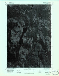 1975 Millinocket SW1979 Print · USGSPenobscot County timberlands and remote waters are captured in this mid-1970s aerial survey. Sportsmen and researchers can trace the detailed shorelines and forest tracks surrounding Nollesemic Lake and the West Branch Penobscot River.2 unique versions available
 - 1975 Map of Lincoln NW, 1980 Print
 1975 Lincoln NW1980 Print · USGSPenobscot County’s deep woods and glacial lakes are captured in this mid-seventies aerial survey of the Maine wilderness. Researchers can trace the timber-hauling networks around Mattamiscontis Mountain or study the shorelines of Mattamiscontis Lake and South Branch Lake.
 - 1975 Map of Millinocket SE, 1980 Print
 1975 Millinocket SE1980 Print · USGSPenobscot County in the mid-seventies reveals the industrial riverfronts of East Millinocket and Medway set against the Maine woods. Trace the path of the West Branch Penobscot River or locate the remote Medunkeunk Lake.
 - 1975 Map of Lincoln NE, 1980 Print
 1975 Lincoln NE1980 Print · USGSPenobscot County timberlands and river corridors are captured in this mid-seventies aerial survey of the Maine woods. Researchers can trace forest management patterns and waterways including the Penobscot River, Pea Ridge, and the Medunkeunk River.
End of results
Showing maps 1-4 of 4
Top cities near T2 R9 NWP
- Lincoln historical maps
- Millinocket historical maps
- East Millinocket historical maps
- Enfield historical maps
- Medway historical maps
- Howland historical maps
See more
Frequently asked questions
- What are the different types of historical maps available for T2 R9 NWP?
- What is the oldest map of T2 R9 NWP?
- Where can I purchase historical maps of T2 R9 NWP for my home or office?
- Where can I download high-res historical maps of T2 R9 NWP?
- Are there historical topographic maps available for T2 R9 NWP?
- Is there historical aerial imagery available for T2 R9 NWP?
- Where are historical maps of T2 R9 NWP sourced from?