Old Maps of Shirley, Maine for Genealogy
Trace your family roots with 36 historic maps of Shirley. These high-res maps reveal old neighborhoods, homesites, landmarks, and streets — helping you uncover where your ancestors lived and how the area evolved over time.
- Explore historic neighborhoods: Identify where your relatives may have lived in the 1800s or 1900s.
- Compare maps over time: Trace the changes in streets, buildings, and landmarks for multi-generational research.
- Perfect for genealogy & ancestry research: Used by family historians and researchers to map out lineage and migration.
These maps are an incredible resource for exploring your personal connection to Shirley's past.
Shirley, ME maps
(36)- 1951 Map of Greenville, 1952 Print
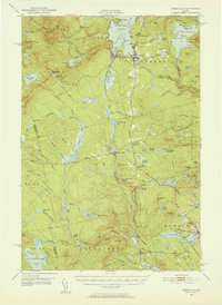 1951 Greenville1952 Print · USGSThe Moosehead Lake region flourished as a rail and timber hub in the early fifties, where the northern woods met the water. Trace the path of the Appalachian Trail or locate the junction of the Canadian Pacific Railroad and Bangor and Aroostook Railroad near Greenville.6 unique versions available
 - 1954 Map of Millinocket, 1968 Print
 1954 Millinocket1968 Print · USGSMaine's North Woods and the Penobscot Valley are captured here during the mid-century era of logging and rail dominance. You can trace the path of the Bangor and Aroostook Railroad through timber towns like Millinocket, Mattawamkeag, and Silver Ridge.3 unique versions available
 - 1958 Map of Millinocket
 1958 Millinocket1958 Print · USGSMaine's North Woods and the Penobscot river valley are captured here in the mid-1950s, showing a landscape of timber, rail, and wild waters. Researchers can trace the legacy of the Canadian Pacific railroad and find historic settlements like Millinocket, Sherman Station, and Mattawamkeag.
 - 1960 Map of Millinocket
 1960 Millinocket1960 Print · USGSThe Maine North Woods and Penobscot River valley are captured at mid-century during the height of the paper milling era. Researchers can trace the Appalachian Trail near Mount Katardin or locate family roots in towns like Dover-Foxcroft and Milo.3 unique versions available
 - 1977 Map of Big Squaw Pond, 1981 Print
 1977 Big Squaw Pond1981 Print · USGSThe timberlands of Piscataquis County appear in stark detail in the late 1970s, as aerial photography captures the high ridges and deep ponds of this Maine wilderness. Researchers can trace the drainages of Squaw Brook and the West Branch Piscataquis River near the shores of Moosehead Lake.
 - 1977 Map of Monson West, 1981 Print
 1977 Monson West1981 Print · USGSPiscataquis County timberlands and lakeside settlements are documented here in the late seventies. Researchers can trace the layout of small communities like Shirley Mills and Monson or locate homesteads near Lake Hebron.
 - 1977 Map of Greenville, 1981 Print
 1977 Greenville1981 Print · USGSThe southern gateway to the Maine North Woods is captured during the late seventies, showing the settlements at the edge of the wilderness. Trace the development of Greenville and Greenville Junction along the shores of Moosehead Lake.
 - 1977 Map of Bald Mountain Pond, 1981 Print
 1977 Bald Mountain Pond1981 Print · USGSPiscataquis County timberlands are captured in this late-seventies aerial survey of the Maine woods near Shirley Mills. Researchers can trace the waterways of the West Branch Piscataquis River and the shores of Bald Mountain Pond.
 - 1986 Map of Dover-Foxcroft
 1986 Dover-Foxcroft1986 Print · USGSPiscataquis County at the edge of the great Maine woods is documented here in the mid-1980s, centered on the river-and-rail hubs of the interior. Trace the industrial footprints of Dover South Mills, the rail yards at Brownville Junction, or the historic Katahdin Iron Works.
 - 1989 Map of Greenville
 1989 Greenville1989 Print · USGSGreenville and the southern reaches of Moosehead Lake are captured in this late-1980s survey during a period of established lakeside settlement. Researchers can locate specific structures and landmarks from Greenville Junction to Upper Shirley Corner, alongside remote features like Rum Mountain and Lower Wilson Pond.2 unique versions available
 - 1989 Map of Bald Mtn Pond
 1989 Bald Mtn Pond1989 Print · USGSThe Maine wilderness in the late eighties is documented here, showing the remote township lines and high ridges of Piscataquis County. You can trace the Appalachian National Scenic Trail past Hatch Falls or locate the historic Shirley Mills and Cem.
 - 1989 Map of Monson West
 1989 Monson West1989 Print · USGSIn the late eighties, this part of Piscataquis County retained its character as a hub for timber history and outdoor recreation. Researchers can trace the routes of the Appalachian National Scenic Trail or locate family sites in Monson, Blanchard, and Shirley Mills.
 - 1989 Map of Big Squaw Pond
 1989 Big Squaw Pond1989 Print · USGSThe Piscataquis County woods are documented here in the late 1980s, showcasing the high ridges and deep bogs west of Greenville. Researchers can trace township boundaries and find remote water bodies like Big Squaw Pond, Ira Bog, and the shorelines of Moosehead Lake.
 - 1994 Map of Dover-Foxcroft
 1994 Dover-Foxcroft1994 Print · USGSCentral Maine in the mid-nineties shows a landscape of timber-driven towns and deep glacial lakes. Trace the paths of the Canadian Pacific RR or locate the Moscow Air Force Station Transmit Site and Sebec Lake.
 - 2011 Map of Monson West, 2011 Print
 2011 Monson West2011 Print · USGSCovers Shirley, including Monson, Blanchard Township, and other nearby areas
 - 2011 Map of Greenville, 2011 Print
 2011 Greenville2011 Print · USGSCovers Shirley, including Greenville, Greenville Junction, and other nearby areas
 - 2011 Map of Bald Mountain Pond, 2011 Print
 2011 Bald Mountain Pond2011 Print · USGSCovers Shirley, including Blanchard Township, Bald Mountain Township, and other nearby areas
 - 2011 Map of Big Moose Pond, 2011 Print
 2011 Big Moose Pond2011 Print · USGSCovers Shirley, including East Moxie Township, Cove Point Township, and other nearby areas
 - 2014 Map of Bald Mountain Pond, 2014 Print
 2014 Bald Mountain Pond2014 Print · USGSCovers Shirley, including Blanchard Township, Bald Mountain Township, and other nearby areas
 - 2014 Map of Big Moose Pond, 2014 Print
 2014 Big Moose Pond2014 Print · USGSCovers Shirley, including East Moxie Township, Cove Point Township, and other nearby areas
 - 2014 Map of Monson West, 2014 Print
 2014 Monson West2014 Print · USGSCovers Shirley, including Monson, Blanchard Township, and other nearby areas
 - 2014 Map of Greenville, 2014 Print
 2014 Greenville2014 Print · USGSCovers Shirley, including Greenville, Greenville Junction, and other nearby areas
 - 2018 Map of Monson West, 2018 Print
 2018 Monson West2018 Print · USGSCovers Shirley, including Monson, Blanchard Township, and other nearby areas
 - 2018 Map of Greenville, 2018 Print
 2018 Greenville2018 Print · USGSCovers Shirley, including Greenville, Greenville Junction, and other nearby areas
 - 2018 Map of Big Moose Pond, 2018 Print
 2018 Big Moose Pond2018 Print · USGSCovers Shirley, including East Moxie Township, Cove Point Township, and other nearby areas
Showing maps 1-25 of 36
Top cities near Shirley
- Greenville historical maps
- Guilford historical maps
- Parkman historical maps
- Abbot historical maps
- Monson historical maps
- Moscow historical maps
See more
Top neighborhoods of Shirley
- Shirley Mills historical maps
- Lower Shirley Corner historical maps
- Upper Shirley Corner historical maps
Frequently asked questions
- What are the different types of historical maps available for Shirley?
- What is the oldest map of Shirley?
- Where can I purchase historical maps of Shirley for my home or office?
- Where can I download high-res historical maps of Shirley?
- Are there historical topographic maps available for Shirley?
- Is there historical aerial imagery available for Shirley?
- Where are historical maps of Shirley sourced from?