1970s Maps of T4 R9 NWP, Maine
Explore 4 historic maps of T4 R9 NWP from the 1970s. These maps offer a rare glimpse into what life looked like during the 1970s — showing old roads, neighborhoods, homes, and landmarks that have changed or disappeared over time.
Whether you're researching your family's past, planning a metal detecting trip, or studying how T4 R9 NWP's landscape evolved across the 1970s, these high-resolution maps are a powerful tool for exploring the history of this region.
- Focus on a specific era: All maps on this page are from the 1970s, giving you a focused view of this time period.
- See what’s changed: Compare century-old streets, trails, and buildings to today's modern landscape using overlays and satellite layers.
- Research with precision: Use these maps for genealogy, historical research, land use analysis, or educational projects.
- View, download, or print: Maps are fully viewable online in high resolution, and can be downloaded or printed for your own records.
Start exploring T4 R9 NWP's history through authentic maps from the 1970s. This is your window into the past.
T4 R9 NWP, ME maps
(4)- 1978 Map of Endless Lake, 1981 Print
 1978 Endless Lake1981 Print · USGSThe Maine woods and interior waterways are captured in detail during the late seventies, showing the area's undisturbed landscape. Researchers can trace the irregular shorelines of Endless Lake and Seboeis Lake or follow the course of Roaring Brook.
 - 1978 Map of Seboeis Lake, 1981 Print
 1978 Seboeis Lake1981 Print · USGSThe Maine North Woods are captured in the late seventies, showing a landscape defined by deep water and timberland. Researchers can trace the exact locations of lakeside outposts like Packards and Schoodic or examine the shorelines of Seboeis Lake.
 - 1978 Map of Cedar Lake, 1981 Print
 1978 Cedar Lake1981 Print · USGSThe Maine North Woods are seen here in the late seventies through detailed aerial orthophotography. Researchers can trace the timber-rich terrain between South Twin Lake and Cedar Lake, following the paths of Grant Brook and Dean Brook.
 - 1978 Map of Ragged Mountain, 1981 Print
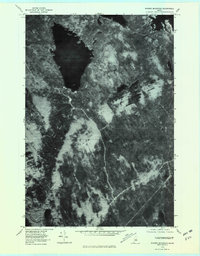 1978 Ragged Mountain1981 Print · USGSPenobscot County timberlands are captured from the air in the late seventies, showing the intersection of Maine's wilderness and its logging industry. Researchers can trace the rail corridor at West Seboois and the shorelines of Upper Jo-Mary Lake and South Twin Lake.2 unique versions available
End of results
Showing maps 1-4 of 4
Top cities near T4 R9 NWP
- Dover-Foxcroft historical maps
- Millinocket historical maps
- Milo historical maps
- Brownville historical maps
- Howland historical maps
- Sebec historical maps
See more
Top neighborhoods of T4 R9 NWP
Frequently asked questions
- What are the different types of historical maps available for T4 R9 NWP?
- What is the oldest map of T4 R9 NWP?
- Where can I purchase historical maps of T4 R9 NWP for my home or office?
- Where can I download high-res historical maps of T4 R9 NWP?
- Are there historical topographic maps available for T4 R9 NWP?
- Is there historical aerial imagery available for T4 R9 NWP?
- Where are historical maps of T4 R9 NWP sourced from?