1970s Maps of Tomhegan Township, Maine
Explore 5 historic maps of Tomhegan Township from the 1970s. These maps offer a rare glimpse into what life looked like during the 1970s — showing old roads, neighborhoods, homes, and landmarks that have changed or disappeared over time.
Whether you're researching your family's past, planning a metal detecting trip, or studying how Tomhegan Township's landscape evolved across the 1970s, these high-resolution maps are a powerful tool for exploring the history of this region.
- Focus on a specific era: All maps on this page are from the 1970s, giving you a focused view of this time period.
- See what’s changed: Compare century-old streets, trails, and buildings to today's modern landscape using overlays and satellite layers.
- Research with precision: Use these maps for genealogy, historical research, land use analysis, or educational projects.
- View, download, or print: Maps are fully viewable online in high resolution, and can be downloaded or printed for your own records.
Start exploring Tomhegan Township's history through authentic maps from the 1970s. This is your window into the past.
Tomhegan Township, ME maps
(5)- 1977 Map of Socatean Bay, 1981 Print
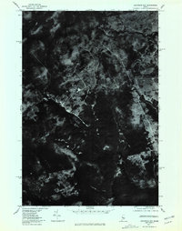 1977 Socatean Bay1981 Print · USGSThe timberlands of Somerset County are captured in the late seventies, showing the intersection of Maine's deep woods and the shoreline. Trace the winding paths of logging roads near Socatean Bay and the drainage of Williams Brook.
 - 1977 Map of Tomhegan Pond, 1981 Print
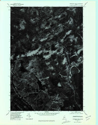 1977 Tomhegan Pond1981 Print · USGSMaine's northern interior remains a quiet landscape of water and wood in the late seventies. You can trace the winding South Branch Penobscot River and examine the natural shorelines of Tomhegan Pond and Center Pond.
 - 1977 Map of Brassua Lake East, 1981 Print
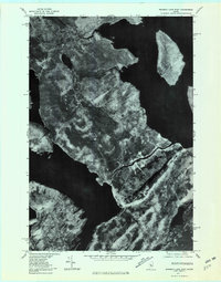 1977 Brassua Lake East1981 Print · USGSThe Maine North Woods and the settlement of Rockwood are shown here in the late seventies. Trace the water system from Brassua Lake along the Moose River to Moosehead Lake and the shores of Farm Island.
 - 1977 Map of Brassua Lake West, 1981 Print
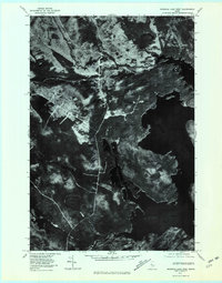 1977 Brassua Lake West1981 Print · USGSThe Maine North Woods in the late seventies come into focus in this detailed orthophotoquad showing the timberlands around Brassua Lake. Researchers can study the historical hydrology and forest cover near Moose River and Tom Fletcher Hill.
 - 1977 Map of North East Carry, 1981 Print
 1977 North East Carry1981 Print · USGSMoosehead Lake and the Maine north woods appear in sharp detail through 1970s aerial photography. Trace the historic portage at North East Carry and locate isolated landmarks like Folsom Farm and the heights of Eagle Mountain.
End of results
Showing maps 1-5 of 5
Top cities near Tomhegan Township
Frequently asked questions
- What are the different types of historical maps available for Tomhegan Township?
- What is the oldest map of Tomhegan Township?
- Where can I purchase historical maps of Tomhegan Township for my home or office?
- Where can I download high-res historical maps of Tomhegan Township?
- Are there historical topographic maps available for Tomhegan Township?
- Is there historical aerial imagery available for Tomhegan Township?
- Where are historical maps of Tomhegan Township sourced from?