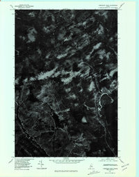
1977 Map of Tomhegan Pond
USGS Topo · Published 1981About this map
Tomhegan Pond and the dense timberlands of Somerset County are captured in this orthophotomap, which utilizes aerial imagery from 1977. Unlike traditional topographic maps, this imagery-based study provides a direct visual of the forest canopy and natural waterways, revealing the complex drainage patterns of Tomhegan Stream. The northern portion of the quadrangle is defined by the winding course of the South Branch Penobscot River, a vital water resource in this sparsely developed interior. The contrast between the open water of Center Pond and the surrounding dark forest floor highlights the isolation of these northern Maine woods during the late 1970s. This specific type of orthophotograph is particularly useful for foresters and land managers to see the exact state of the woodland and logging road networks before later changes in industrial land use.
Find a feature on this map
4 named features on this map. Tap any name to fly to it.
Don’t see what you’re looking for? This feature index may not catch every label — zoom into the map to look around manually.
Map Details
Editions of this 1977 Tomhegan Pond Map
This is the sole edition of this map. No revisions or reprints were ever made.
Other maps of this area

1921 · Brassua Lake
USGS Topo · 1:62,500

1922 · Long Pond
USGS Topo · 1:62,500

1923 · Brassua Lake
USGS Topo · 1:62,500

1924 · Long Pond
USGS Topo · 1:62,500

1944 · Brassua Lake
USGS Topo · 1:62,500

1944 · Long Pond
USGS Topo · 1:62,500

1949 · Jackman
USGS Topo · 1:250,000

1954 · Seboomook Lake
USGS Topo · 1:62,500

1954 · Millinocket
USGS Topo · 1:250,000

1956 · Penobscot Lake
USGS Topo · 1:62,500
Featured Places
- Tomhegan Township, ME
- West Middlesex Canal Grant Township, ME
- Pittston Academy Grant, ME
- Plymouth Township, ME
- Brassua Township, ME