1950s Maps of Kittery Point, Kittery
Explore 8 historic maps of Kittery Point from the 1950s. These maps offer a rare glimpse into what life looked like during the 1950s — showing old roads, neighborhoods, homes, and landmarks that have changed or disappeared over time.
Whether you're researching your family's past, planning a metal detecting trip, or studying how Kittery Point's landscape evolved across the 1950s, these high-resolution maps are a powerful tool for exploring the history of this region.
- Focus on a specific era: All maps on this page are from the 1950s, giving you a focused view of this time period.
- See what’s changed: Compare century-old streets, trails, and buildings to today's modern landscape using overlays and satellite layers.
- Research with precision: Use these maps for genealogy, historical research, land use analysis, or educational projects.
- View, download, or print: Maps are fully viewable online in high resolution, and can be downloaded or printed for your own records.
Start exploring Kittery Point's history through authentic maps from the 1950s. This is your window into the past.
Kittery Point, Kittery maps
(8)- 1956 Map of Kittery, 1957 Print
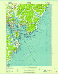 1956 Kittery1957 Print · USGSThe Maine and New Hampshire coastlines meet here in the mid-1950s, a landscape shaped by centuries of maritime defense and growing suburban neighborhoods. Genealogists and historians can trace the foundations of Kittery and New Castle, locating landmarks like Fort McClary State Park and the Whaleback Lighthouse.5 unique versions available
 - 1956 Map of Isles Of Shoals, 1957 Print
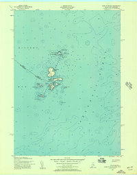 1956 Isles Of Shoals1957 Print · USGSThe offshore islands of York County and Rockingham County are captured in this mid-century maritime survey. Genealogists and historians can trace the settlement of Gosport on Star Island and locate landmarks like the White Island Lighthouse and the ledges of Duck Island.2 unique versions available
 - 1956 Map of York, 1960 Print
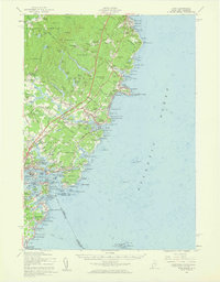 1956 York1960 Print · USGSThe Maine coastline in the mid-fifties shows a world of historic harbor defenses and growing seaside resorts. Genealogists can trace family names at Brixham Upper Corners, locate the First Parish Ch, and explore the shoreline from York Cliffs to Kittery.4 unique versions available
 - 1956 Map of Portland, 1963 Print
 1956 Portland1963 Print · USGSSouthern Maine and eastern New Hampshire are captured here in the mid-fifties, during a time of major highway expansion and military growth. You can trace the path of the Maine Turnpike and locate landmarks like the Portsmouth Naval Shipyard and Sebago Lake.4 unique versions available
 - 1956 Map of Isles of Shoals, 1964 Print
 1956 Isles of Shoals1964 Print · USGSThe Isles of Shoals are captured here in the mid-1950s, detailing the maritime boundary between Maine and New Hampshire. Researchers can locate island landmarks such as Tucke Mon, the Lighthouse on White Island, and the settlement at Appledore.
 - 1956 Map of Boston, 1967 Print
 1956 Boston1967 Print · USGSThe Massachusetts coastline and industrial interior are seen here during the mid-century peak of suburban and highway expansion. Researchers can trace historic harbor defenses like Fort Revere, local landmarks such as Faneuil Hall, and the vast Parker River National Wildlife Refuge.6 unique versions available
 - 1958 Map of Boston
 1958 Boston1958 Print · USGSEastern Massachusetts and southern New Hampshire are shown at the height of the industrial era, before the full expansion of the interstate system. Trace coastal defenses at Fort Warren, historic rail lines like the Boston and Maine, and the development of the Mass. 128 corridor.2 unique versions available
 - 1959 Map of Portland
 1959 Portland1959 Print · USGSThe Maine and New Hampshire coastlines meet in this mid-century portrait of maritime commerce and inland rail networks. Researchers can trace the legacy of coastal defense at Fort Williams and follow the historic path of the Maine Central RR through the White Mountain National Forest.2 unique versions available
End of results
Showing maps 1-8 of 8
Frequently asked questions
- What are the different types of historical maps available for Kittery Point?
- What is the oldest map of Kittery Point?
- Where can I purchase historical maps of Kittery Point for my home or office?
- Where can I download high-res historical maps of Kittery Point?
- Are there historical topographic maps available for Kittery Point?
- Is there historical aerial imagery available for Kittery Point?
- Where are historical maps of Kittery Point sourced from?