1920s Maps of Charles County, Maryland
Explore 5 historic maps of Charles County from the 1920s. These maps offer a rare glimpse into what life looked like during the 1920s — showing old roads, neighborhoods, homes, and landmarks that have changed or disappeared over time.
Whether you're researching your family's past, planning a metal detecting trip, or studying how Charles County's landscape evolved across the 1920s, these high-resolution maps are a powerful tool for exploring the history of this region.
- Focus on a specific era: All maps on this page are from the 1920s, giving you a focused view of this time period.
- See what’s changed: Compare century-old streets, trails, and buildings to today's modern landscape using overlays and satellite layers.
- Research with precision: Use these maps for genealogy, historical research, land use analysis, or educational projects.
- View, download, or print: Maps are fully viewable online in high resolution, and can be downloaded or printed for your own records.
Start exploring Charles County's history through authentic maps from the 1920s. This is your window into the past.
Charles County, MD maps
(5)- 1920 Map of Wicomico
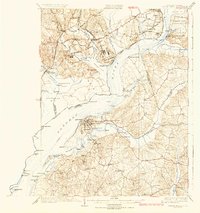
 1920 Wicomico1920 Print · USGSThe Potomac and Wicomico riverfronts appear here as they were just after the Great War, when steamboat wharves and ferries still anchored local commerce. Trace the old rail lines to Bel Alton Cox Sta or locate long-standing landmarks like Charlotte Hall and Ludlow Ferry.
 - 1923 Map of Indian Head
 1923 Indian Head1923 Print · USGSMaryland and Virginia meet along the Potomac in the 1920s, a period when steamboats and early highways still defined regional travel. Genealogists can trace family footprints through sites like Marshall Hall PO, Pohick Church, and the Woodlawn School (Colored).2 unique versions available
 - 1925 Map of Indian Head
 1925 Indian Head1925 Print · USGSThe Potomac River corridor in the mid-1920s reveals a landscape of strategic military installations and historic river landings. Genealogists and local historians can trace the foundations of Indian Head, find local landmarks like Pohick Church, or locate defunct river hubs such as Budds Ferry.6 unique versions available
 - 1926 Map of Stafford, 1956 Print
 1926 Stafford1956 Print · USGSStafford County and the Rappahannock River valley appear here in the mid-twenties, balancing colonial-era heritage with early twentieth-century growth. Genealogists can locate family landmarks like Bridges Store, Passapatanzy, and the historic Aquia Ch along the rail lines.
 - 1927 Map of Quantico
 1927 Quantico1927 Print · USGSPrince William County and the Potomac riverfront appear here in the late twenties, captured just as military and transit corridors began to reshape the rural landscape. Researchers can trace the early foundations of the Marine Corps Reservation and locate vanished local landmarks like Minnieville Store and the Sinclairs Mill.
End of results
Showing maps 1-5 of 5
Top cities of Charles County
- Waldorf historical maps
- Bennsville historical maps
- La Plata historical maps
- Bryans Road historical maps
- Indian Head historical maps
- Cobb Island historical maps
See more
Frequently asked questions
- What are the different types of historical maps available for Charles County?
- What is the oldest map of Charles County?
- Where can I purchase historical maps of Charles County for my home or office?
- Where can I download high-res historical maps of Charles County?
- Are there historical topographic maps available for Charles County?
- Is there historical aerial imagery available for Charles County?
- Where are historical maps of Charles County sourced from?